|
|
|
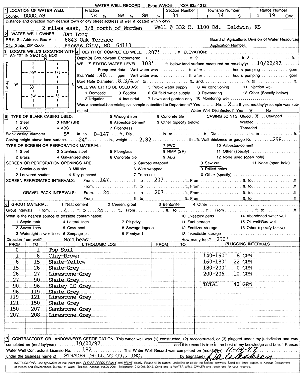
Specific Water Well Detail |
|
|
| Location Info | |||
| Owner: Long, Jan | Status: Constructed | ||
| Location: T14S, R19E, Sec. 34, NE NW SW | County: Douglas | ||
| Directions: 322 E 1100 Rd, Baldwin - from Worden: 2 mi E, .38 mi N | |||
| Latitude: 38.788692 | Longitude: -95.2938416 | Datum NAD 27 | |
| Latitude: 38.7886982 | Longitude: -95.2940935 | Datum NAD 83 | |
| Longitude and latitude calculated by Survey from township-range-section-quarter calls. Only good to within the quarter call accuracy. | |||
| View well on interactive map | |||
| General Info | ||
| Well Depth: 207 ft. | Elevation: ft. | |
| Static Water Level: 103 ft. | Est. Yield: 40 gpm. | |
| Comp. Date: 22-Oct-1997 | Well Use: Domestic | |
| DWR Applic. #: | Other ID: | |
| Driller Info | ||
| Driller: Strader Drilling Co., Inc. | License #: 182 | |
| Scanned Form | View scan |
|
Chemical Sample Submitted?: No
Water Well disinfected?: | ||
| Ground water encountered: 0 ft. , 0 ft. , 0 ft. | ||
| Pump test data: Well water was 0 ft after 0 hours pumping 0 gpm | ||
| Casing Info | ||
| Casing Type: PVC
Casing Joints: |
Diam: 5 in. to 147 ft
Diam: 0 in. to 0 ft Diam: 0 in. to 0 ft | |
| Casing height above land surface: in
Casing Weight: lbs/ft Wall thickness or gauge no.: | ||
| Screen and Perforation Info | ||
| Screen Type: PVC | Screen Openings: Saw cut | |
| Screen-perforated intervals | From: 147 ft to 207 ft
From: 0 ft to 0 ft From: 0 ft to 0 ft | |
| Gravel pack intervals | From: ft to ft | |
| Grout Info | ||
| Grout used: Bentonite | From: 4 to 24 ft
From: 0 to 0 ft From: 0 to 0 ft | |
| Source of Possible Contamination | ||
| Source: Septic Tank | ||
| Direction from well: NE | Distance: 250 ft | |
| Lithologic Log
(Log data entered by KGS.) | ||
| From: 0 ft. to 1 ft. | top soil | |
| From: 1 ft. to 6 ft. | clay, brown | |
| From: 6 ft. to 15 ft. | shale, yellow | |
| From: 15 ft. to 26 ft. | shale, gray | |
| From: 26 ft. to 27 ft. | limestone, gray | |
| From: 27 ft. to 90 ft. | shale, gray | |
| From: 90 ft. to 96 ft. | shaley limestone, gray | |
| From: 96 ft. to 119 ft. | shale, gray | |
| From: 119 ft. to 121 ft. | limestone, gray | |
| From: 121 ft. to 150 ft. | shale, gray | |
| From: 150 ft. to 207 ft. | sandstone, gray | |
| From: 207 ft. to 208 ft. | limestone, gray | |