|
|
|
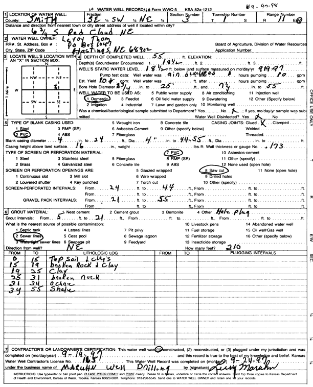
Specific Water Well Detail |
|
|
| Location Info | |||
| Owner: Thom, Leroy | Status: Constructed | ||
| Location: T1S, R11W, Sec. 3, SE SW NE | County: Smith | ||
| Directions: from Red Cloud, NE, 6.75 mi S | |||
| Latitude: 39.9959481 | Longitude: -98.5477286 | Datum NAD 27 | |
| Latitude: 39.9959617 | Longitude: -98.5480676 | Datum NAD 83 | |
| Longitude and latitude calculated by Survey from township-range-section-quarter calls. Only good to within the quarter call accuracy. | |||
| View well on interactive map | |||
| General Info | ||
| Well Depth: 55 ft. | Elevation: ft. | |
| Static Water Level: 18.5 ft. | Est. Yield: 10 gpm. | |
| Comp. Date: 19-Sep-1997 | Well Use: Domestic | |
| DWR Applic. #: | Other ID: | |
| Driller Info | ||
| Driller: Leroy Maruhn Well Drilling, Inc. | License #: 165 | |
| Scanned Form | View scan |
|
Chemical Sample Submitted?: No
Water Well disinfected?: | ||
| Ground water encountered: 18.5 ft. , 0 ft. , 0 ft. | ||
| Pump test data: Well water was 0 ft after 0 hours pumping 0 gpm | ||
| Casing Info | ||
| Casing Type: PVC
Casing Joints: |
Diam: 4 in. to 24 ft
Diam: 4 in. to 44 ft Diam: 4 in. to 55 ft | |
| Casing height above land surface: in
Casing Weight: lbs/ft Wall thickness or gauge no.: | ||
| Screen and Perforation Info | ||
| Screen Type: PVC | Screen Openings: Saw cut | |
| Screen-perforated intervals | From: 24 ft to 44 ft
From: 0 ft to 0 ft From: 0 ft to 0 ft | |
| Gravel pack intervals | From: ft to ft | |
| Grout Info | ||
| Grout used: | From: 5 to 21 ft
From: 0 to 0 ft From: 0 to 0 ft | |
| Source of Possible Contamination | ||
| Source: Sewer lines | ||
| Direction from well: NE | Distance: 210 ft | |
| Lithologic Log
(Log data entered by KGS.) | ||
| From: 0 ft. to 15 ft. | top soil and clays | |
| From: 15 ft. to 19 ft. | broken rock and clay | |
| From: 19 ft. to 25 ft. | clay | |
| From: 25 ft. to 31 ft. | broken rock | |
| From: 31 ft. to 34 ft. | ochre | |
| From: 34 ft. to 55 ft. | shale | |