|
|
|
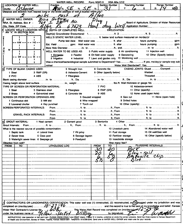
Specific Water Well Detail |
|
|
| Location Info | |||
| Owner: Guttery, Brice | Status: Plugged | ||
| Location: T6S, R14W, Sec. 31, NW SE SE | County: Osborne | ||
| Directions: From Alton, 2 miles East | |||
| Latitude: 39.4834409 | Longitude: -98.9182972 | Datum NAD 27 | |
| Latitude: 39.4834514 | Longitude: -98.9186571 | Datum NAD 83 | |
| Longitude and latitude calculated by Survey from township-range-section-quarter calls. Only good to within the quarter call accuracy. | |||
| View well on interactive map | |||
| General Info | ||
| Well Depth: 30 ft. | Elevation: ft. | |
| Static Water Level: ft. | Est. Yield: gpm. | |
| Comp. Date: 27-Oct-1996 | Well Use: Domestic | |
| DWR Applic. #: | Other ID: | |
| Driller Info | ||
| Driller: Yellow Jacket Drilling | License #: 608 | |
| Scanned Form | View scan |
| Casing Info | ||
|
Casing Type: OTHER
Diam: 60 in. Casing height above land surface: in | ||
| Grout Info | ||
| Grout used: Bentonite | From: 6 to 5.5 ft
From: 0 to 0 ft From: 0 to 0 ft | |
| Source of Possible Contamination | ||
| Source: | ||
| Direction from well: | Distance: 0 ft | |