|
|
|
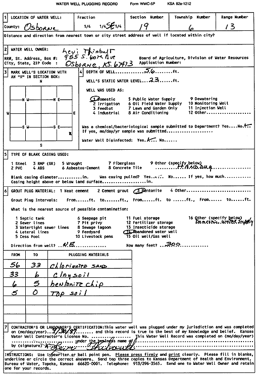
Specific Water Well Detail |
|
|
| Location Info | |||
| Owner: Thibault, Levi | Status: Plugged | ||
| Location: T6S, R13W, Sec. 19, SE | County: Osborne | ||
| Directions: | |||
| Latitude: 39.5142994 | Longitude: -98.8088234 | Datum NAD 27 | |
| Latitude: 39.5143101 | Longitude: -98.8091784 | Datum NAD 83 | |
| Longitude and latitude calculated by Survey from township-range-section-quarter calls. Only good to within the quarter call accuracy. | |||
| View well on interactive map | |||
| General Info | ||
| Well Depth: 56 ft. | Elevation: ft. | |
| Static Water Level: 23 ft. | Est. Yield: gpm. | |
| Comp. Date: 30-Sep-1997 | Well Use: Domestic | |
| DWR Applic. #: | Other ID: | |
| Driller Info | ||
| Driller: well owner | License #: | |
| Scanned Form | View scan |
| Casing Info | ||
|
Casing Type: OTHER
Diam: 40 in. Casing height above land surface: in | ||
| Grout Info | ||
| Grout used: Bentonite | From: 6 to 5 ft
From: 0 to 0 ft From: 0 to 0 ft | |
| Source of Possible Contamination | ||
| Source: Abandoned water well | ||
| Direction from well: NE | Distance: 300 ft | |