|
|
|
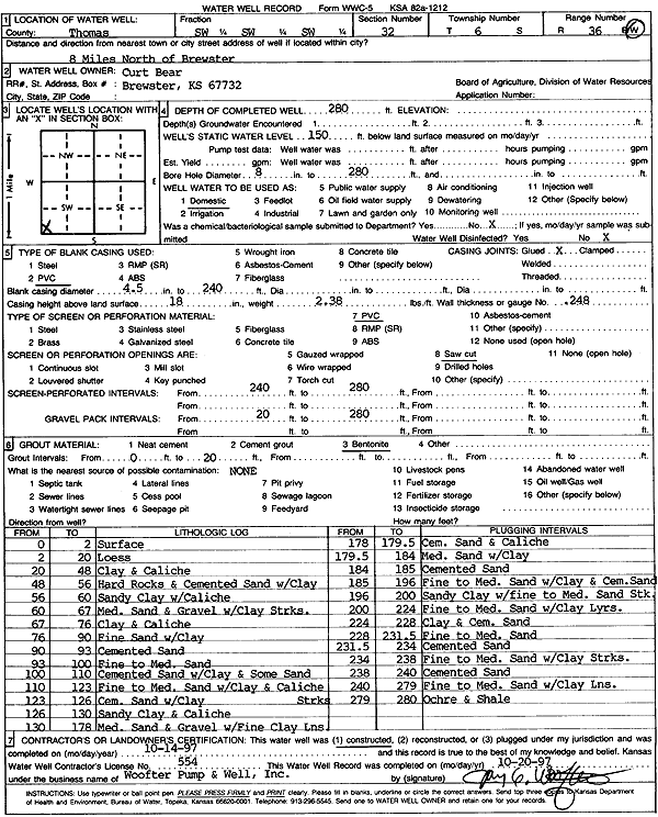
Specific Water Well Detail |
|
|
| Location Info | |||
| Owner: Bear, Curt | Status: Constructed | ||
| Location: T6S, R36W, Sec. 32, SW SW SW | County: Thomas | ||
| Directions: from Brewster: 8 mi N | |||
| Latitude: 39.4835198 | Longitude: -101.3702308 | Datum NAD 27 | |
| Latitude: 39.4835199 | Longitude: -101.3706717 | Datum NAD 83 | |
| Longitude and latitude calculated by Survey from township-range-section-quarter calls. Only good to within the quarter call accuracy. | |||
| View well on interactive map | |||
| General Info | ||
| Well Depth: 280 ft. | Elevation: ft. | |
| Static Water Level: 150 ft. | Est. Yield: gpm. | |
| Comp. Date: 14-Oct-1997 | Well Use: Domestic | |
| DWR Applic. #: | Other ID: | |
| Driller Info | ||
| Driller: Jay C. Woofter Pump & Well, Inc. | License #: 554 | |
| Scanned Form | View scan |
|
Chemical Sample Submitted?: No
Water Well disinfected?: | ||
| Ground water encountered: 0 ft. , 0 ft. , 0 ft. | ||
| Pump test data: Well water was 0 ft after 0 hours pumping 0 gpm | ||
| Casing Info | ||
| Casing Type: PVC
Casing Joints: |
Diam: 4.5 in. to 240 ft
Diam: 0 in. to 0 ft Diam: 0 in. to 0 ft | |
| Casing height above land surface: in
Casing Weight: lbs/ft Wall thickness or gauge no.: | ||
| Screen and Perforation Info | ||
| Screen Type: PVC | Screen Openings: Saw cut | |
| Screen-perforated intervals | From: 240 ft to 280 ft
From: 0 ft to 0 ft From: 0 ft to 0 ft | |
| Gravel pack intervals | From: ft to ft | |
| Grout Info | ||
| Grout used: Bentonite | From: 0 to 20 ft
From: 0 to 0 ft From: 0 to 0 ft | |
| Source of Possible Contamination | ||
| Source: | ||
| Direction from well: | Distance: 0 ft | |
| Lithologic Log
(Log data entered by KGS.) | ||
| From: 0 ft. to 2 ft. | surface | |
| From: 2 ft. to 20 ft. | loess | |
| From: 20 ft. to 48 ft. | clay and caliche | |
| From: 48 ft. to 56 ft. | hard rocks and cemented sand with clay | |
| From: 56 ft. to 60 ft. | sandy clay with caliche | |
| From: 60 ft. to 67 ft. | medium sand and gravel with clay streaks | |
| From: 67 ft. to 76 ft. | clay and caliche | |
| From: 76 ft. to 90 ft. | fine sand with clay | |
| From: 90 ft. to 93 ft. | cemented sand | |
| From: 93 ft. to 100 ft. | fine to medium sand | |
| From: 100 ft. to 110 ft. | cemented sand with clay and some sand | |
| From: 110 ft. to 123 ft. | fine to medium sand with clay and caliche streaks | |
| From: 123 ft. to 126 ft. | cemented sand with clay | |
| From: 126 ft. to 130 ft. | sandy clay and caliche | |
| From: 130 ft. to 178 ft. | medium sand and gravel with fine clay lens | |
| From: 178 ft. to 179.5 ft. | cemented sand and caliche | |
| From: 179.5 ft. to 184 ft. | medium sand with clay | |
| From: 184 ft. to 185 ft. | cemented sand | |
| From: 185 ft. to 196 ft. | fine to medium sand with clay and cemented sand | |
| From: 196 ft. to 200 ft. | sandy clay with fine to medium sand streaks | |
| From: 200 ft. to 224 ft. | fine to medium sand with clay layers | |
| From: 224 ft. to 228 ft. | clay and cemented sand | |
| From: 228 ft. to 231.5 ft. | fine to medium sand | |
| From: 231.5 ft. to 234 ft. | cemented sand | |
| From: 234 ft. to 238 ft. | fine to medium sand with clay streaks | |
| From: 238 ft. to 240 ft. | cemented sand | |
| From: 240 ft. to 279 ft. | fine to medium sand with clay lens | |
| From: 279 ft. to 280 ft. | ochre and shale | |