|
|
|
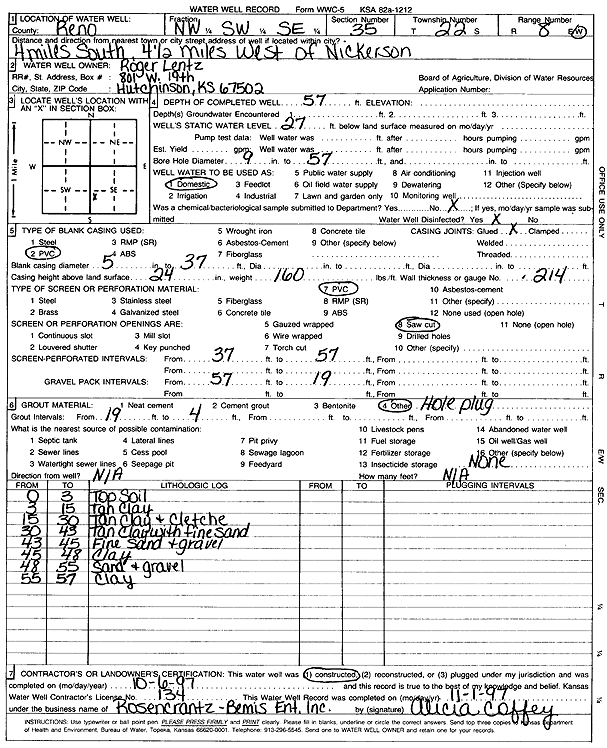
Specific Water Well Detail |
|
|
| Location Info | |||
| Owner: Lentz, Roger | Status: Constructed | ||
| Location: T22S, R8W, Sec. 35, NW SW SE | County: Reno | ||
| Directions: from Nickerson: 4 mi S, 4.5 mi W | |||
| Latitude: 38.0892464 | Longitude: -98.168321 | Datum NAD 27 | |
| Latitude: 38.0892585 | Longitude: -98.1686596 | Datum NAD 83 | |
| Longitude and latitude calculated by Survey from township-range-section-quarter calls. Only good to within the quarter call accuracy. | |||
| View well on interactive map | |||
| General Info | ||
| Well Depth: 57 ft. | Elevation: ft. | |
| Static Water Level: 27 ft. | Est. Yield: gpm. | |
| Comp. Date: 06-Oct-1997 | Well Use: Domestic | |
| DWR Applic. #: | Other ID: | |
| Driller Info | ||
| Driller: Rosencrantz-Bemis Enterprises, Inc. | License #: 134 | |
| Scanned Form | View scan |
|
Chemical Sample Submitted?: No
Water Well disinfected?: | ||
| Ground water encountered: 0 ft. , 0 ft. , 0 ft. | ||
| Pump test data: Well water was 0 ft after 0 hours pumping 0 gpm | ||
| Casing Info | ||
| Casing Type: PVC
Casing Joints: |
Diam: 5 in. to 37 ft
Diam: 0 in. to 0 ft Diam: 0 in. to 0 ft | |
| Casing height above land surface: in
Casing Weight: lbs/ft Wall thickness or gauge no.: | ||
| Screen and Perforation Info | ||
| Screen Type: PVC | Screen Openings: Saw cut | |
| Screen-perforated intervals | From: 37 ft to 57 ft
From: 0 ft to 0 ft From: 0 ft to 0 ft | |
| Gravel pack intervals | From: ft to ft | |
| Grout Info | ||
| Grout used: | From: 19 to 4 ft
From: 0 to 0 ft From: 0 to 0 ft | |
| Source of Possible Contamination | ||
| Source: | ||
| Direction from well: | Distance: 0 ft | |
| Lithologic Log
(Log data entered by KGS.) | ||
| From: 0 ft. to 3 ft. | top soil | |
| From: 3 ft. to 15 ft. | tan clay | |
| From: 15 ft. to 30 ft. | tan clay and caliche | |
| From: 30 ft. to 43 ft. | tan clay with fine sand | |
| From: 43 ft. to 45 ft. | fine sand and gravel | |
| From: 45 ft. to 48 ft. | clay | |
| From: 48 ft. to 55 ft. | sand and gravel | |
| From: 55 ft. to 57 ft. | clay | |