|
|
|
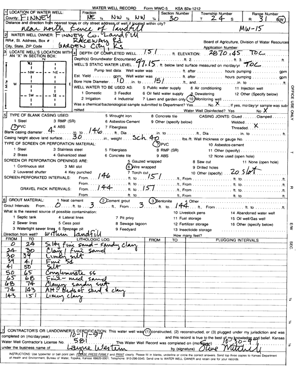
Specific Water Well Detail |
|
|
| Location Info | |||
| Owner: Finney County Landfill | Status: Constructed | ||
| Location: T24S, R31W, Sec. 30, NE NW NW | County: Finney | ||
| Directions: near N fence of landfill | |||
| Latitude: 37.9447471 | Longitude: -100.7703755 | Datum NAD 27 | |
| Latitude: 37.9447695 | Longitude: -100.7708114 | Datum NAD 83 | |
| Longitude and latitude calculated by Survey from township-range-section-quarter calls. Only good to within the quarter call accuracy. | |||
| View well on interactive map | |||
| General Info | ||
| Well Depth: 151 ft. | Elevation: 2870.45 ft. | |
| Static Water Level: 97.15 ft. | Est. Yield: gpm. | |
| Comp. Date: 17-Oct-1997 | Well Use: Monitoring well/observation/piezometer | |
| DWR Applic. #: | Other ID: MW 15 | |
| Driller Info | ||
| Driller: Layne Western | License #: 581 | |
| Scanned Form | View scan |
|
Chemical Sample Submitted?: No
Water Well disinfected?: | ||
| Ground water encountered: 0 ft. , 0 ft. , 0 ft. | ||
| Pump test data: Well water was 0 ft after 0 hours pumping 0 gpm | ||
| Casing Info | ||
| Casing Type: PVC
Casing Joints: |
Diam: 4 in. to 146 ft
Diam: 0 in. to 0 ft Diam: 0 in. to 0 ft | |
| Casing height above land surface: in
Casing Weight: lbs/ft Wall thickness or gauge no.: | ||
| Screen and Perforation Info | ||
| Screen Type: PVC | Screen Openings: Wire wrapped | |
| Screen-perforated intervals | From: 146 ft to 151 ft
From: 0 ft to 0 ft From: 0 ft to 0 ft | |
| Gravel pack intervals | From: ft to ft | |
| Grout Info | ||
| Grout used: Cement grout, Bentonite | From: 0 to 3 ft
From: 3 to 144 ft From: 0 to 0 ft | |
| Source of Possible Contamination | ||
| Source: | ||
| Direction from well: | Distance: 0 ft | |
| Lithologic Log
(Log data entered by KGS.) | ||
| From: 0 ft. to 24 ft. | silty fine sand - sandy clay | |
| From: 24 ft. to 30 ft. | clay / fine sand | |
| From: 30 ft. to 39 ft. | limey silt | |
| From: 39 ft. to 41 ft. | fine sd | |
| From: 41 ft. to 50 ft. | silt | |
| From: 50 ft. to 65 ft. | conglomerate SS | |
| From: 65 ft. to 68 ft. | fine - medium sand | |
| From: 68 ft. to 74 ft. | clayey sandy silt | |
| From: 74 ft. to 143 ft. | alt. beds of sand and clay | |
| From: 143 ft. to 151 ft. | limey clay | |