|
|
|
Specific Water Well Detail |
|
|
| Location Info | |||
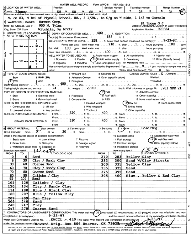
| Owner: Hummon Corp. | Status: Constructed | ||
| Location: T25S, R34W, Sec. 15, SW SW SE | County: Finney | ||
| Directions: 1 mi N of Plymell school, 8 W, 3.5 N, to C/g on W, 1.5 to corral | |||
| Latitude: 37.8737895 | Longitude: -101.0371968 | Datum NAD 27 | |
| Latitude: 37.8738128 | Longitude: -101.0376429 | Datum NAD 83 | |
| Longitude and latitude calculated by Survey from township-range-section-quarter calls. Only good to within the quarter call accuracy. | |||
| View well on interactive map | |||
| General Info | ||
| Well Depth: 400 ft. | Elevation: ft. | |
| Static Water Level: 158 ft. | Est. Yield: 100 gpm. | |
| Comp. Date: 23-Sep-1997 | Well Use: Oil Field Water Supply | |
| DWR Applic. #: 970384 | Other ID: O.J. Brown 1 | |
| Links | |
| No Wizard information available. | |
| View info from WIMAS Water Right Data base... | |
| Driller Info | ||
| Driller: Howard Drilling Company AG, LLC | License #: 430 | |
| Scanned Form | View scan |
|
Chemical Sample Submitted?: No
Water Well disinfected?: | ||
| Ground water encountered: 158 ft. , 0 ft. , 0 ft. | ||
| Pump test data: Well water was 0 ft after 0 hours pumping 0 gpm | ||
| Casing Info | ||
| Casing Type: PVC
Casing Joints: |
Diam: 6 in. to 400 ft
Diam: 0 in. to 0 ft Diam: 0 in. to 0 ft | |
| Casing height above land surface: in
Casing Weight: lbs/ft Wall thickness or gauge no.: | ||
| Screen and Perforation Info | ||
| Screen Type: PVC | Screen Openings: Saw cut | |
| Screen-perforated intervals | From: 320 ft to 400 ft
From: 0 ft to 0 ft From: 0 ft to 0 ft | |
| Gravel pack intervals | From: ft to ft | |
| Grout Info | ||
| Grout used: Neat cement, | From: 0 to 20 ft
From: 0 to 0 ft From: 0 to 0 ft | |
| Source of Possible Contamination | ||
| Source: Oil well/gas well | ||
| Direction from well: W | Distance: 150 ft | |
| Lithologic Log
(Log data entered by KGS.) | ||
| From: 0 ft. to 6 ft. | sand | |
| From: 6 ft. to 30 ft. | clay / sandy clay | |
| From: 30 ft. to 60 ft. | coarse sand | |
| From: 60 ft. to 70 ft. | clay / sandy clay | |
| From: 70 ft. to 80 ft. | coarse sand | |
| From: 80 ft. to 85 ft. | caliche / clay | |
| From: 85 ft. to 105 ft. | sand | |
| From: 105 ft. to 120 ft. | caliche / clay | |
| From: 120 ft. to 134 ft. | clay / sandy clay | |
| From: 134 ft. to 180 ft. | blue / black clay | |
| From: 180 ft. to 207 ft. | blue / yellow clay | |
| From: 207 ft. to 209 ft. | tan clay | |
| From: 209 ft. to 240 ft. | sand | |
| From: 240 ft. to 247 ft. | clay | |
| From: 247 ft. to 270 ft. | coarse sand | |
| From: 270 ft. to 283 ft. | yellow clay | |
| From: 283 ft. to 300 ft. | sand with clay streaks | |
| From: 300 ft. to 335 ft. | yellow clay | |
| From: 335 ft. to 375 ft. | sand | |
| From: 375 ft. to 395 ft. | sand | |
| From: 395 ft. to 400 ft. | blue, yellow and red clay | |