|
|
|
Specific Water Well Detail |
|
|
| Location Info | |||
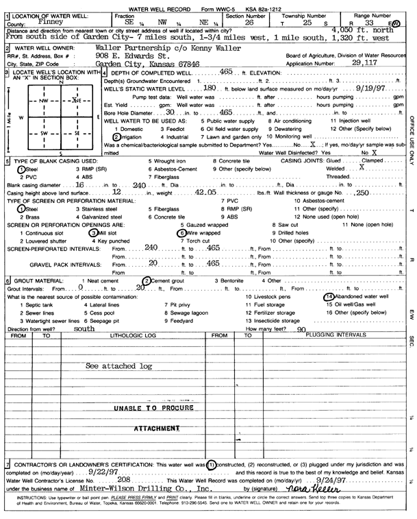
| Owner: Waller Partnership | Status: Constructed | ||
| Location: T25S, R33W, Sec. 26, SE NW NE | County: Finney | ||
| Directions: from S side of Garden City: 7 mi S, 1.75 mi W, 1 mi S, 4050 feet N, and 1320 feet W | |||
| Latitude: 37.8560172 | Longitude: -100.9072622 | Datum NAD 27 | |
| Latitude: 37.8560409 | Longitude: -100.9077044 | Datum NAD 83 | |
| Longitude and latitude calculated by Survey from township-range-section-quarter calls. Only good to within the quarter call accuracy. | |||
| View well on interactive map | |||
| General Info | ||
| Well Depth: 465 ft. | Elevation: ft. | |
| Static Water Level: 180 ft. | Est. Yield: gpm. | |
| Comp. Date: 22-Sep-1997 | Well Use: Irrigation | |
| DWR Applic. #: 29117 | Other ID: | |
| Links | |
| No Wizard information available. | |
| View info from WIMAS Water Right Data base... | |
| Driller Info | ||
| Driller: Minter-Wilson Drlg. Co., Inc. | License #: 208 | |
| Scanned Form | View scan |
|
Chemical Sample Submitted?: No
Water Well disinfected?: | ||
| Ground water encountered: 0 ft. , 0 ft. , 0 ft. | ||
| Pump test data: Well water was 0 ft after 0 hours pumping 0 gpm | ||
| Casing Info | ||
| Casing Type: Steel
Casing Joints: |
Diam: 16 in. to 240 ft
Diam: 0 in. to 0 ft Diam: 0 in. to 0 ft | |
| Casing height above land surface: in
Casing Weight: lbs/ft Wall thickness or gauge no.: | ||
| Screen and Perforation Info | ||
| Screen Type: Steel | Screen Openings: Mill slot | |
| Screen-perforated intervals | From: 240 ft to 465 ft
From: 0 ft to 0 ft From: 0 ft to 0 ft | |
| Gravel pack intervals | From: ft to ft | |
| Grout Info | ||
| Grout used: Cement grout | From: 0 to 20 ft
From: 0 to 0 ft From: 0 to 0 ft | |
| Source of Possible Contamination | ||
| Source: Abandoned water well | ||
| Direction from well: S | Distance: 90 ft | |
| Lithologic Log
(log data not edited or checked by the KGS.) | ||
| From: 0 ft. to 15 ft. | Type: CLAY | |
| From: 15 ft. to 22 ft. | Type: SANDY CLAY | |
| From: 22 ft. to 28 ft. | Type: FINE SAND | |
| From: 28 ft. to 37 ft. | Type: CLAY | |
| From: 37 ft. to 41 ft. | Type: FINE SAND | |
| From: 41 ft. to 46 ft. | Type: CLAY | |
| From: 46 ft. to 188 ft. | Type: COARSE GRAVEL | |
| From: 188 ft. to 200 ft. | Type: SAND & GRAVEL | |
| From: 200 ft. to 215 ft. | Type: CLAY | |
| From: 215 ft. to 260 ft. | Type: SAND & GRAVEL | |
| From: 260 ft. to 281 ft. | Type: MEDIUM GRAVEL | |
| From: 281 ft. to 318 ft. | Type: SANDY CLAY | |
| From: 318 ft. to 343 ft. | Type: SAND & GRAVEL | |
| From: 343 ft. to 356 ft. | Type: SANDY CLAY | |
| From: 356 ft. to 359 ft. | Type: FINE SAND | |
| From: 359 ft. to 398 ft. | Type: SANDY CLAY | |
| From: 398 ft. to 405 ft. | Type: SAND & GRAVEL | |
| From: 405 ft. to 408 ft. | Type: SANDY CLAY | |
| From: 408 ft. to 413 ft. | Type: SAND & GRAVEL | |
| From: 413 ft. to 427 ft. | Type: SANDY CLAY | |
| From: 427 ft. to 458 ft. | Type: CLAY | |
| From: 458 ft. to 470 ft. | Type: SHALE | |