|
|
|
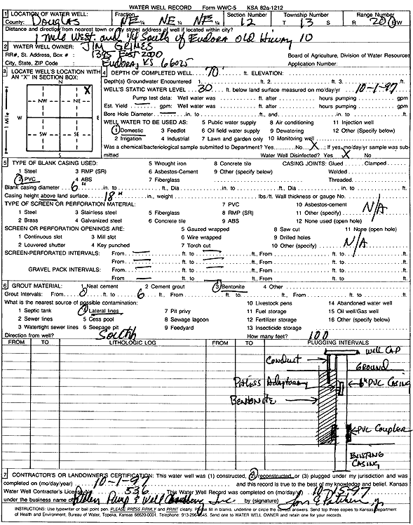
Specific Water Well Detail |
|
|
| Location Info | |||
| Owner: Grimes, Jim | Status: Reconstructed | ||
| Location: T13S, R20E, Sec. 12, NE NE NE | County: Douglas | ||
| Directions: from Eudora: 1 mi W, .25 mi S on old Hwy 10 | |||
| Latitude: 38.9414635 | Longitude: -95.1311381 | Datum NAD 27 | |
| Latitude: 38.9414673 | Longitude: -95.1313863 | Datum NAD 83 | |
| Longitude and latitude calculated by Survey from township-range-section-quarter calls. Only good to within the quarter call accuracy. | |||
| View well on interactive map | |||
| General Info | ||
| Well Depth: 70 ft. | Elevation: ft. | |
| Static Water Level: 30 ft. | Est. Yield: gpm. | |
| Comp. Date: 01-Oct-1997 | Well Use: Domestic | |
| DWR Applic. #: | Other ID: | |
| Driller Info | ||
| Driller: Tom Patchen Pump & Well Drlg. | License #: 536 | |
| Scanned Form | View scan |
|
Chemical Sample Submitted?: No
Water Well disinfected?: | ||
| Ground water encountered: 0 ft. , 0 ft. , 0 ft. | ||
| Pump test data: Well water was 0 ft after 0 hours pumping 0 gpm | ||
| Casing Info | ||
| Casing Type: PVC
Casing Joints: |
Diam: 6 in. to 0 ft
Diam: 0 in. to 0 ft Diam: 0 in. to 0 ft | |
| Casing height above land surface: in
Casing Weight: lbs/ft Wall thickness or gauge no.: | ||
| Screen and Perforation Info | ||
| Screen Type: OTHER | Screen Openings: OTHER | |
| Screen-perforated intervals | From: 999 ft to 999 ft
From: 0 ft to 0 ft From: 0 ft to 0 ft | |
| Gravel pack intervals | From: ft to ft | |
| Grout Info | ||
| Grout used: Bentonite | From: 0 to 6 ft
From: 0 to 0 ft From: 0 to 0 ft | |
| Source of Possible Contamination | ||
| Source: Lateral lines | ||
| Direction from well: S | Distance: 100 ft | |