|
|
|
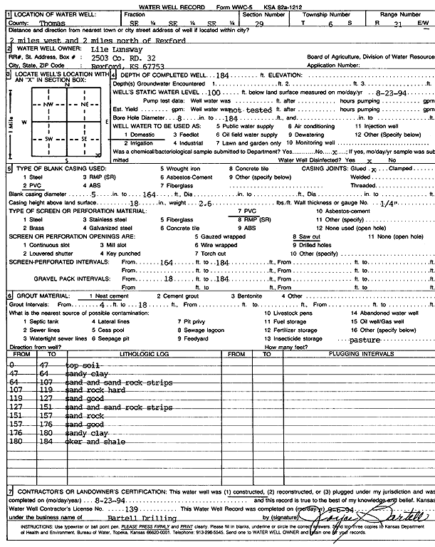
Specific Water Well Detail |
|
|
| Location Info | |||
| Owner: Lunsway, Lile | Status: Constructed | ||
| Location: T6S, R31W, Sec. 29, SE SE SE | County: Thomas | ||
| Directions: from Rexford: 2 mi W, 2 mi N | |||
| Latitude: 39.4973003 | Longitude: -100.7959462 | Datum NAD 27 | |
| Latitude: 39.497304 | Longitude: -100.7963735 | Datum NAD 83 | |
| Longitude and latitude calculated by Survey from township-range-section-quarter calls. Only good to within the quarter call accuracy. | |||
| View well on interactive map | |||
| General Info | ||
| Well Depth: 184 ft. | Elevation: ft. | |
| Static Water Level: 100 ft. | Est. Yield: gpm. | |
| Comp. Date: 23-Aug-1994 | Well Use: Domestic | |
| DWR Applic. #: | Other ID: | |
| Driller Info | ||
| Driller: Bartell Drilling & Machine Works | License #: 139 | |
| Scanned Form | View scan |
|
Chemical Sample Submitted?: No
Water Well disinfected?: | ||
| Ground water encountered: 0 ft. , 0 ft. , 0 ft. | ||
| Pump test data: Well water was 0 ft after 0 hours pumping 0 gpm | ||
| Casing Info | ||
| Casing Type: PVC
Casing Joints: |
Diam: 5 in. to 164 ft
Diam: 0 in. to 0 ft Diam: 0 in. to 0 ft | |
| Casing height above land surface: in
Casing Weight: lbs/ft Wall thickness or gauge no.: | ||
| Screen and Perforation Info | ||
| Screen Type: PVC | Screen Openings: Saw cut | |
| Screen-perforated intervals | From: 164 ft to 184 ft
From: 0 ft to 0 ft From: 0 ft to 0 ft | |
| Gravel pack intervals | From: ft to ft | |
| Grout Info | ||
| Grout used: Neat cement | From: 4 to 18 ft
From: 0 to 0 ft From: 0 to 0 ft | |
| Source of Possible Contamination | ||
| Source: OTHER | ||
| Direction from well: | Distance: 0 ft | |
| Lithologic Log
(Log data entered by KGS.) | ||
| From: 0 ft. to 47 ft. | Top soil | |
| From: 47 ft. to 64 ft. | Sandy clay | |
| From: 64 ft. to 107 ft. | Sand and sand rock strips | |
| From: 107 ft. to 119 ft. | Sand rock hard | |
| From: 119 ft. to 127 ft. | Sand good | |
| From: 127 ft. to 151 ft. | Sand and sand rock strips | |
| From: 151 ft. to 157 ft. | Sand rock | |
| From: 157 ft. to 176 ft. | Sand good | |
| From: 176 ft. to 180 ft. | Sandy clay | |
| From: 180 ft. to 184 ft. | Ochre and shale | |