|
|
|
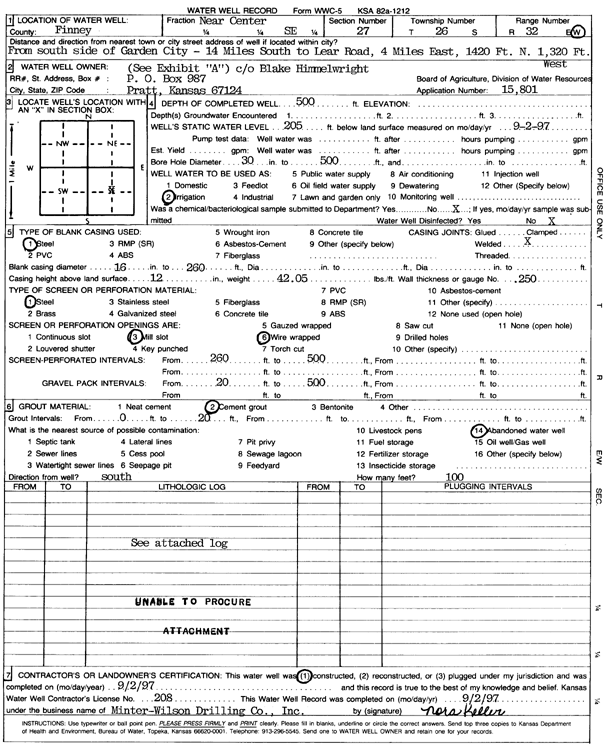
Specific Water Well Detail |
|
|
| Location Info | |||
| Owner: Himmelwright, Blake | Status: Constructed | ||
| Location: T26S, R32W, Sec. 27, C SE | County: Finney | ||
| Directions: from Garden City: 14 mi S to Lear Rd, 4 mi E, 1420 feet N, and 1320 feet W | |||
| Latitude: 37.7548977 | Longitude: -100.8021556 | Datum NAD 27 | |
| Latitude: 37.7549216 | Longitude: -100.8025946 | Datum NAD 83 | |
| Longitude and latitude calculated by Survey from township-range-section-quarter calls. Only good to within the quarter call accuracy. | |||
| View well on interactive map | |||
| General Info | ||
| Well Depth: 500 ft. | Elevation: ft. | |
| Static Water Level: 205 ft. | Est. Yield: gpm. | |
| Comp. Date: 02-Sep-1997 | Well Use: Irrigation | |
| DWR Applic. #: 15801 | Other ID: | |
| Links | |
| View info from Wizard Water Level Data base... | |
| View info from WIMAS Water Right Data base... | |
| Driller Info | ||
| Driller: Minter-Wilson Drlg. Co., Inc. | License #: 208 | |
| Scanned Form | View scan |
|
Chemical Sample Submitted?: No
Water Well disinfected?: | ||
| Ground water encountered: 0 ft. , 0 ft. , 0 ft. | ||
| Pump test data: Well water was 0 ft after 0 hours pumping 0 gpm | ||
| Casing Info | ||
| Casing Type: Steel
Casing Joints: |
Diam: 16 in. to 260 ft
Diam: 0 in. to 0 ft Diam: 0 in. to 0 ft | |
| Casing height above land surface: in
Casing Weight: lbs/ft Wall thickness or gauge no.: | ||
| Screen and Perforation Info | ||
| Screen Type: Steel | Screen Openings: Mill slot | |
| Screen-perforated intervals | From: 260 ft to 500 ft
From: 0 ft to 0 ft From: 0 ft to 0 ft | |
| Gravel pack intervals | From: ft to ft | |
| Grout Info | ||
| Grout used: Cement grout | From: 0 to 20 ft
From: 0 to 0 ft From: 0 to 0 ft | |
| Source of Possible Contamination | ||
| Source: Abandoned water well | ||
| Direction from well: S | Distance: 100 ft | |
| Lithologic Log
(Log data entered by KGS.) | ||
| From: 0 ft. to 1 ft. | clay | |
| From: 1 ft. to 63 ft. | fine sand | |
| From: 63 ft. to 69 ft. | sand and gravel | |
| From: 69 ft. to 93 ft. | medium gravel | |
| From: 93 ft. to 125 ft. | clay | |
| From: 125 ft. to 128 ft. | sand and gravel | |
| From: 128 ft. to 141 ft. | sandy clay | |
| From: 141 ft. to 152 ft. | shale | |
| From: 152 ft. to 163 ft. | sandy clay | |
| From: 163 ft. to 174 ft. | sand and gravel | |
| From: 174 ft. to 185 ft. | sandy clay | |
| From: 185 ft. to 258 ft. | clay | |
| From: 258 ft. to 284 ft. | sand and gravel | |
| From: 284 ft. to 289 ft. | sandy clay | |
| From: 289 ft. to 315 ft. | sand and gravel | |
| From: 315 ft. to 324 ft. | sandy clay | |
| From: 324 ft. to 334 ft. | sand and gravel | |
| From: 334 ft. to 371 ft. | sandy clay | |
| From: 371 ft. to 379 ft. | fine sand | |
| From: 379 ft. to 450 ft. | sandy clay | |
| From: 450 ft. to 477 ft. | clay | |
| From: 477 ft. to 490 ft. | sand and gravel | |
| From: 490 ft. to 512 ft. | clay | |
| From: 512 ft. to 515 ft. | shale | |