|
|
|
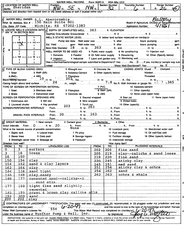
Specific Water Well Detail |
|
|
| Location Info | |||
| Owner: A.L. Abercrombie | Status: Constructed | ||
| Location: T6S, R26W, Sec. 32, NW SE NW | County: Sheridan | ||
| Directions: | |||
| Latitude: 39.4899011 | Longitude: -100.2498126 | Datum NAD 27 | |
| Latitude: 39.4899044 | Longitude: -100.2502276 | Datum NAD 83 | |
| Longitude and latitude calculated by Survey from township-range-section-quarter calls. Only good to within the quarter call accuracy. | |||
| View well on interactive map | |||
| General Info | ||
| Well Depth: 263 ft. | Elevation: ft. | |
| Static Water Level: ft. | Est. Yield: gpm. | |
| Comp. Date: 20-Jun-1997 | Well Use: Irrigation | |
| DWR Applic. #: 41,851 | Other ID: | |
| Links | |
| No Wizard information available. | |
| View info from WIMAS Water Right Data base... | |
| Driller Info | ||
| Driller: Woofter Pump & Well, Inc. | License #: 554 | |
| Scanned Form | View scan |
|
Chemical Sample Submitted?: No
Water Well disinfected?: | ||
| Ground water encountered: 0 ft. , 0 ft. , 0 ft. | ||
| Pump test data: Well water was 0 ft after 0 hours pumping 0 gpm | ||
| Casing Info | ||
| Casing Type: PVC
Casing Joints: |
Diam: 10 in. to 203 ft
Diam: 0 in. to 0 ft Diam: 0 in. to 0 ft | |
| Casing height above land surface: in
Casing Weight: lbs/ft Wall thickness or gauge no.: | ||
| Screen and Perforation Info | ||
| Screen Type: PVC | Screen Openings: Saw cut | |
| Screen-perforated intervals | From: 203 ft to 263 ft
From: 0 ft to 0 ft From: 0 ft to 0 ft | |
| Gravel pack intervals | From: ft to ft | |
| Grout Info | ||
| Grout used: Bentonite | From: 0 to 20 ft
From: 0 to 0 ft From: 0 to 0 ft | |
| Source of Possible Contamination | ||
| Source: | ||
| Direction from well: | Distance: 0 ft | |
| Lithologic Log
(Log data entered by KGS.) | ||
| From: 0 ft. to 3 ft. | Surface | |
| From: 3 ft. to 16 ft. | Loess | |
| From: 150 ft. to 154 ft. | Clay | |
| From: 154 ft. to 162 ft. | Sand and clay layers | |
| From: 162 ft. to 164 ft. | Clay | |
| From: 164 ft. to 166 ft. | Tight sand | |
| From: 166 ft. to 169 ft. | Sandy clay | |
| From: 169 ft. to 177 ft. | Cemented sand, caliche, sand streaks | |
| From: 177 ft. to 182 ft. | Tight fine sand slightly cemented | |
| From: 182 ft. to 199 ft. | Green and brown clay, caliche streaks | |
| From: 199 ft. to 200 ft. | Sand | |
| From: 200 ft. to 202 ft. | Clay | |
| From: 202 ft. to 205 ft. | Fine sand | |
| From: 205 ft. to 219 ft. | Clay, caliche and sand loess | |
| From: 219 ft. to 220 ft. | Fine sand | |
| From: 220 ft. to 245 ft. | Sticky clay | |
| From: 245 ft. to 251 ft. | Medium sand | |
| From: 251 ft. to 254 ft. | Sticky clay and ochre | |
| From: 254 ft. to 262 ft. | Sand | |
| From: 262 ft. to 263 ft. | Ochre, shale | |