|
|
|
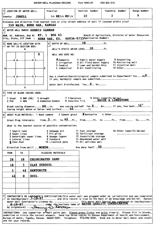
Specific Water Well Detail |
|
|
| Location Info | |||
| Owner: Garman, Dennis | Status: Plugged | ||
| Location: T2S, R9W, Sec. 22, NE NE NE | County: Jewell | ||
| Directions: 559 Main St, Burr Oak | |||
| Latitude: 39.8705813 | Longitude: -98.3069308 | Datum NAD 27 | |
| Latitude: 39.8705943 | Longitude: -98.3072615 | Datum NAD 83 | |
| Longitude and latitude calculated by Survey from township-range-section-quarter calls. Only good to within the quarter call accuracy. | |||
| View well on interactive map | |||
| General Info | ||
| Well Depth: 28 ft. | Elevation: ft. | |
| Static Water Level: 10 ft. | Est. Yield: gpm. | |
| Comp. Date: 19-Jul-1997 | Well Use: Domestic | |
| DWR Applic. #: | Other ID: | |
| Driller Info | ||
| Driller: Water Quality Coordinator | License #: | |
| Scanned Form | View scan |
| Casing Info | ||
|
Casing Type: OTHER
Diam: 60 in. Casing height above land surface: in | ||
| Grout Info | ||
| Grout used: Bentonite | From: 5 to 4.5 ft
From: 0 to 0 ft From: 0 to 0 ft | |
| Source of Possible Contamination | ||
| Source: Cess pool | ||
| Direction from well: N | Distance: 50 ft | |