|
|
|
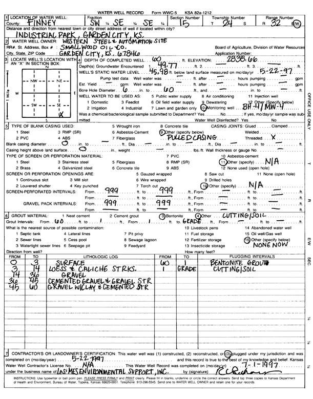
Specific Water Well Detail |
|
|
| Location Info | |||
| Owner: Western Steel & Automation Site | Status: Plugged | ||
| Location: T24S, R32W, Sec. 15, SW SE SE | County: Finney | ||
| Directions: Industrial Park, Garden City | |||
| Latitude: 37.9612229 | Longitude: -100.813635 | Datum NAD 27 | |
| Latitude: 37.9612455 | Longitude: -100.8140724 | Datum NAD 83 | |
| Longitude and latitude calculated by Survey from township-range-section-quarter calls. Only good to within the quarter call accuracy. | |||
| View well on interactive map | |||
| General Info | ||
| Well Depth: 60 ft. | Elevation: 2838.66 ft. | |
| Static Water Level: 45.98 ft. | Est. Yield: gpm. | |
| Comp. Date: 22-May-1997 | Well Use: Monitoring well/observation/piezometer | |
| DWR Applic. #: | Other ID: MW 4 | |
| Driller Info | ||
| Driller: unknown | License #: | |
| Scanned Form | View scan |
| Casing Info | ||
|
Casing Type: OTHER
Diam: 0 in. Casing height above land surface: in | ||
| Grout Info | ||
| Grout used: Bentonite, | From: 60 to 1 ft
From: 1 to 0 ft From: 0 to 0 ft | |
| Source of Possible Contamination | ||
| Source: OTHER | ||
| Direction from well: | Distance: 0 ft | |