|
|
|
Specific Water Well Detail |
|
|
| Location Info | |||
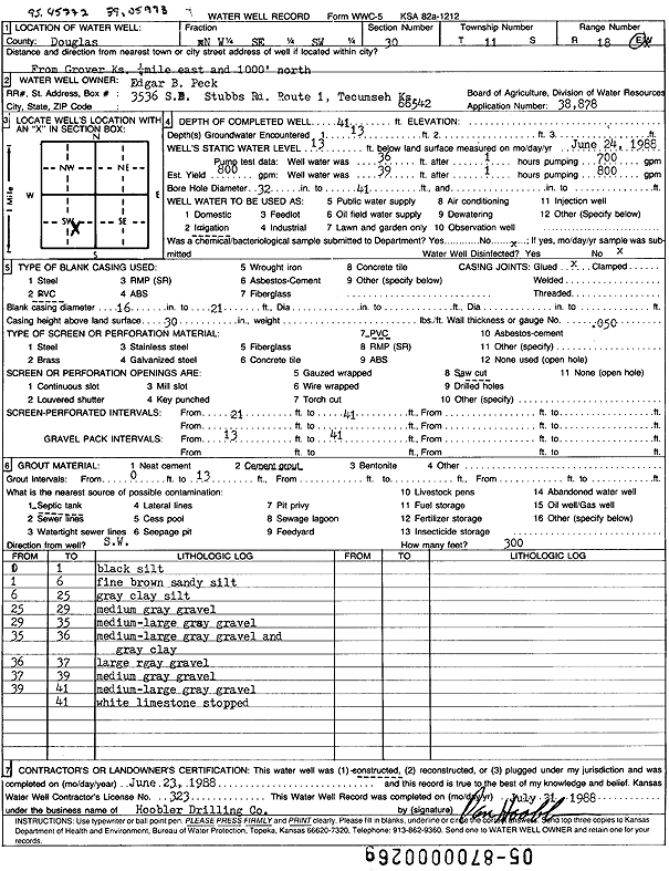
| Owner: Peck, Edgar B. | Status: Constructed | ||
| Location: T11S, R18E, Sec. 30, NW SE SW | County: Douglas | ||
| Directions: from Grover: .25 mi E, 1000' N | |||
| Latitude: 39.0608323 | Longitude: -95.4588101 | Datum NAD 27 | |
| Latitude: 39.0608325 | Longitude: -95.4590634 | Datum NAD 83 | |
| Longitude and latitude calculated by Survey from township-range-section-quarter calls. Only good to within the quarter call accuracy. | |||
| View well on interactive map | |||
| General Info | ||
| Well Depth: 41 ft. | Elevation: ft. | |
| Static Water Level: 13 ft. | Est. Yield: 800 gpm. | |
| Comp. Date: 23-Jun-1988 | Well Use: Irrigation | |
| DWR Applic. #: 38878 | Other ID: | |
| Links | |
| No Wizard information available. | |
| View info from WIMAS Water Right Data base... | |
| Driller Info | ||
| Driller: Daniel H. Hoobler Drilling Co. | License #: 323 | |
| Scanned Form | View scan |
|
Chemical Sample Submitted?: No
Water Well disinfected?: | ||
| Ground water encountered: 13 ft. , 0 ft. , 0 ft. | ||
| Pump test data: Well water was 36 ft after 1 hours pumping 700 gpm | ||
| Casing Info | ||
| Casing Type: PVC
Casing Joints: |
Diam: 16 in. to 21 ft
Diam: 0 in. to 0 ft Diam: 0 in. to 0 ft | |
| Casing height above land surface: in
Casing Weight: lbs/ft Wall thickness or gauge no.: | ||
| Screen and Perforation Info | ||
| Screen Type: PVC | Screen Openings: Saw cut | |
| Screen-perforated intervals | From: 21 ft to 41 ft
From: 0 ft to 0 ft From: 0 ft to 0 ft | |
| Gravel pack intervals | From: ft to ft | |
| Grout Info | ||
| Grout used: | From: 0 to 13 ft
From: 0 to 0 ft From: 0 to 0 ft | |
| Source of Possible Contamination | ||
| Source: Septic Tank | ||
| Direction from well: | Distance: 0 ft | |
| Lithologic Log
(Log data entered by KGS.) | ||
| From: 0 ft. to 1 ft. | Black silt | |
| From: 1 ft. to 6 ft. | Fine brown sandy silt | |
| From: 6 ft. to 25 ft. | Gray clay silt | |
| From: 25 ft. to 29 ft. | Medium gray gravel | |
| From: 29 ft. to 35 ft. | Medium-large gray gravel | |
| From: 35 ft. to 36 ft. | Medium-large gray gravel and gray clay | |
| From: 36 ft. to 37 ft. | Large gray gravel | |
| From: 37 ft. to 39 ft. | Medium Gray gravel | |
| From: 39 ft. to 41 ft. | Medium-large gray gravel | |
| From: 41 ft. to ft. | White limestone | |