|
|
|
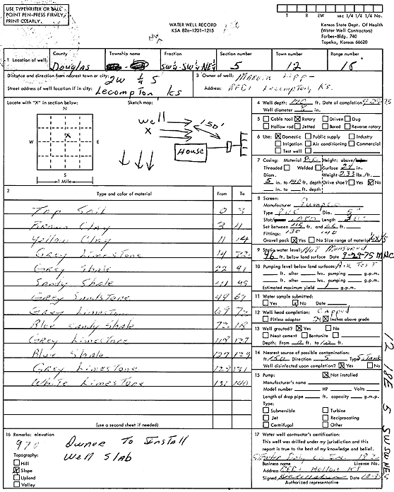
Specific Water Well Detail |
|
|
| Location Info | |||
| Owner: Lipp, Marvin | Status: Constructed | ||
| Location: T12S, R18E, Sec. 5, SW SW NE | County: Douglas | ||
| Directions: from Lecompton: 2 mi W, .25 mi S | |||
| Latitude: 39.0374609 | Longitude: -95.4364256 | Datum NAD 27 | |
| Latitude: 39.0374613 | Longitude: -95.4366787 | Datum NAD 83 | |
| Longitude and latitude calculated by Survey from township-range-section-quarter calls. Only good to within the quarter call accuracy. | |||
| View well on interactive map | |||
| General Info | ||
| Well Depth: 140 ft. | Elevation: ft. | |
| Static Water Level: 46 ft. | Est. Yield: 1 gpm. | |
| Comp. Date: 29-Sep-1975 | Well Use: Domestic | |
| DWR Applic. #: | Other ID: | |
| Driller Info | ||
| Driller: Strader Drilling Co., Inc. | License #: 182 | |
| Scanned Form | View scan |
|
Chemical Sample Submitted?: No
Water Well disinfected?: | ||
| Ground water encountered: 0 ft. , 0 ft. , 0 ft. | ||
| Pump test data: Well water was 0 ft after 0 hours pumping 0 gpm | ||
| Casing Info | ||
| Casing Type:
Casing Joints: |
Diam: 0 in. to 0 ft
Diam: 0 in. to 0 ft Diam: 0 in. to 0 ft | |
| Casing height above land surface: in
Casing Weight: lbs/ft Wall thickness or gauge no.: | ||
| Screen and Perforation Info | ||
| Screen Type: | Screen Openings: | |
| Screen-perforated intervals | From: 45 ft to 65 ft
From: 100 ft to 140 ft From: 0 ft to 0 ft | |
| Gravel pack intervals | From: ft to ft | |
| Grout Info | ||
| Grout used: | From: 0 to 0 ft
From: 0 to 0 ft From: 0 to 0 ft | |
| Source of Possible Contamination | ||
| Source: | ||
| Direction from well: | Distance: 0 ft | |
| Lithologic Log
(Log data entered by KGS.) | ||
| From: 0 ft. to 3 ft. | Top soil | |
| From: 3 ft. to 11 ft. | Brown clay | |
| From: 11 ft. to 14 ft. | Yellow clay | |
| From: 14 ft. to 22 ft. | Gray limestone | |
| From: 22 ft. to 41 ft. | Gray shale | |
| From: 41 ft. to 49 ft. | Sandy shale | |
| From: 49 ft. to 69 ft. | Gray sandstone | |
| From: 69 ft. to 72 ft. | Gray limestone | |
| From: 72 ft. to 118 ft. | Blue sandy shale | |
| From: 118 ft. to 127 ft. | Gray limestone | |
| From: 127 ft. to 129 ft. | Blue shale | |
| From: 129 ft. to 131 ft. | Gray limestone | |
| From: 131 ft. to 140 ft. | White limestone | |