|
|
|
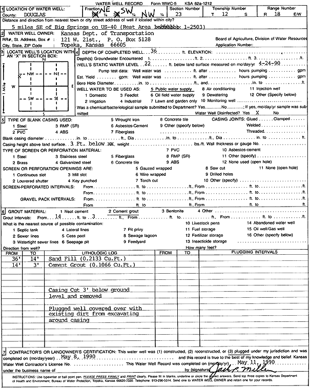
Specific Water Well Detail |
|
|
| Location Info | |||
| Owner: Kansas Dept. of Transportation | Status: Plugged | ||
| Location: T12S, R18E, Sec. 23, NE SW NW | County: Douglas | ||
| Directions: from Big Springs: 5 mi SE on US 40, Rest Area 1-2503 | |||
| Latitude: 38.9959293 | Longitude: -95.3875208 | Datum NAD 27 | |
| Latitude: 38.9959304 | Longitude: -95.3877734 | Datum NAD 83 | |
| Longitude and latitude calculated by Survey from township-range-section-quarter calls. Only good to within the quarter call accuracy. | |||
| View well on interactive map | |||
| General Info | ||
| Well Depth: 36 ft. | Elevation: ft. | |
| Static Water Level: 22 ft. | Est. Yield: gpm. | |
| Comp. Date: 08-May-1990 | Well Use: Public Water Supply | |
| DWR Applic. #: | Other ID: | |
| Driller Info | ||
| Driller: KDOT | License #: | |
| Scanned Form | View scan |
| Casing Info | ||
|
Casing Type: Steel
Diam: 5 in. Casing height above land surface: in | ||
| Grout Info | ||
| Grout used: Cement grout | From: 3 to 14 ft
From: 0 to 0 ft From: 0 to 0 ft | |
| Source of Possible Contamination | ||
| Source: OTHER | ||
| Direction from well: | Distance: 0 ft | |