|
|
|
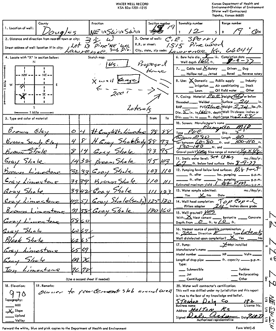
Specific Water Well Detail |
|
|
| Location Info | |||
| Owner: Sperry, C.E. | Status: Constructed | ||
| Location: T12S, R19E, Sec. 19, NE SW SW | County: Douglas | ||
| Directions: from Lawrence: 3.5 mi W, Lot 13, Pine NE Wa. Subdivision | |||
| Latitude: 38.9885601 | Longitude: -95.3500993 | Datum NAD 27 | |
| Latitude: 38.9885614 | Longitude: -95.3503513 | Datum NAD 83 | |
| Longitude and latitude calculated by Survey from township-range-section-quarter calls. Only good to within the quarter call accuracy. | |||
| View well on interactive map | |||
| General Info | ||
| Well Depth: 160 ft. | Elevation: ft. | |
| Static Water Level: 67 ft. | Est. Yield: 1 gpm. | |
| Comp. Date: 09-Aug-1977 | Well Use: Domestic | |
| DWR Applic. #: | Other ID: | |
| Driller Info | ||
| Driller: Strader Drilling Co., Inc. | License #: 182 | |
| Scanned Form | View scan |
|
Chemical Sample Submitted?: No
Water Well disinfected?: | ||
| Ground water encountered: 0 ft. , 0 ft. , 0 ft. | ||
| Pump test data: Well water was 0 ft after 0 hours pumping 0 gpm | ||
| Casing Info | ||
| Casing Type:
Casing Joints: |
Diam: 0 in. to 0 ft
Diam: 0 in. to 0 ft Diam: 0 in. to 0 ft | |
| Casing height above land surface: in
Casing Weight: lbs/ft Wall thickness or gauge no.: | ||
| Screen and Perforation Info | ||
| Screen Type: | Screen Openings: | |
| Screen-perforated intervals | From: 60 ft to 80 ft
From: 100 ft to 110 ft From: 130 ft to 140 ft | |
| Gravel pack intervals | From: ft to ft | |
| Grout Info | ||
| Grout used: | From: 0 to 0 ft
From: 0 to 0 ft From: 0 to 0 ft | |
| Source of Possible Contamination | ||
| Source: | ||
| Direction from well: | Distance: 0 ft | |
| Lithologic Log
(Log data entered by KGS.) | ||
| From: 0 ft. to 4 ft. | brown clay | |
| From: 4 ft. to 8 ft. | brown sandy clay | |
| From: 9 ft. to 14 ft. | brown shale | |
| From: 14 ft. to 32 ft. | gray shale | |
| From: 32 ft. to 33 ft. | brown limestone | |
| From: 33 ft. to 39 ft. | gray limestone | |
| From: 39 ft. to 42 ft. | gray shale | |
| From: 42 ft. to 51 ft. | gray limestone | |
| From: 51 ft. to 58 ft. | brown limestone | |
| From: 58 ft. to 60 ft. | gray limestone | |
| From: 60 ft. to 62 ft. | gray shale | |
| From: 62 ft. to 65 ft. | black shale | |
| From: 65 ft. to 69 ft. | gray limestone | |
| From: 69 ft. to 76 ft. | gray shale | |
| From: 76 ft. to 78 ft. | tan limestone | |
| From: 78 ft. to 88 ft. | light gray-white limestone | |
| From: 88 ft. to 93 ft. | light gray sandy shale | |
| From: 93 ft. to 95 ft. | gray shale | |
| From: 95 ft. to 103 ft. | brown shale | |
| From: 103 ft. to 110 ft. | gray shale | |
| From: 110 ft. to 111 ft. | brown shale | |
| From: 111 ft. to 123 ft. | gray shale | |
| From: 123 ft. to 130 ft. | gray sandy shale | |
| From: 130 ft. to 160 ft. | gray shale | |