|
|
|
Specific Water Well Detail |
|
|
| Location Info | |||
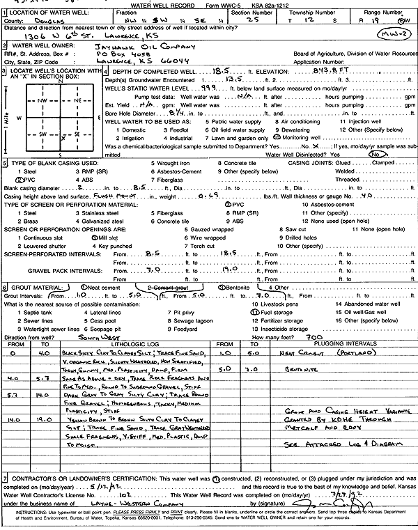
| Owner: Jayhawk Oil Co, Inc. | Status: Constructed | ||
| Location: T12S, R19E, Sec. 25, NW SW SE | County: Douglas | ||
| Directions: 1306 W 6th St, Lawrence | |||
| Latitude: 38.9742461 | Longitude: -95.2496086 | Datum NAD 27 | |
| Latitude: 38.9742482 | Longitude: -95.249859 | Datum NAD 83 | |
| Longitude and latitude calculated by Survey from township-range-section-quarter calls. Only good to within the quarter call accuracy. | |||
| View well on interactive map | |||
| General Info | ||
| Well Depth: 18.5 ft. | Elevation: 843.8 ft. | |
| Static Water Level: ft. | Est. Yield: gpm. | |
| Comp. Date: 12-May-1992 | Well Use: Monitoring well/observation/piezometer | |
| DWR Applic. #: | Other ID: MW 2 | |
| Driller Info | ||
| Driller: Layne-Christensen Co. | License #: 102 | |
| Scanned Form | View scan |
|
Chemical Sample Submitted?: No
Water Well disinfected?: | ||
| Ground water encountered: 13 ft. , 0 ft. , 0 ft. | ||
| Pump test data: Well water was 0 ft after 0 hours pumping 0 gpm | ||
| Casing Info | ||
| Casing Type: PVC
Casing Joints: |
Diam: 2 in. to 8 ft
Diam: 0 in. to 0 ft Diam: 0 in. to 0 ft | |
| Casing height above land surface: in
Casing Weight: lbs/ft Wall thickness or gauge no.: | ||
| Screen and Perforation Info | ||
| Screen Type: PVC | Screen Openings: Mill slot | |
| Screen-perforated intervals | From: 8 ft to 18 ft
From: 0 ft to 0 ft From: 0 ft to 0 ft | |
| Gravel pack intervals | From: ft to ft | |
| Grout Info | ||
| Grout used: Neat cement | From: 1 to 4 ft
From: 4 to 7 ft From: 0 to 0 ft | |
| Source of Possible Contamination | ||
| Source: Fuel storage | ||
| Direction from well: | Distance: 0 ft | |
| Lithologic Log
(Log data entered by KGS.) | ||
| From: 0 ft. to 4 ft. | black silty clay to clayey silt, trace fine sand, very organic rich, slightly weathered, non stratified, tacky gummy, medium plasticity, damp, firm | |
| From: 4 ft. to 5.7 ft. | black silty clay to clayey silt, trace fine sand, dry, trace rock fragments and fine to medium gravel, round to subround, stiff | |
| From: 5.7 ft. to 14 ft. | dark gray to gray silty clay, trace round fine gravel, homogeneous, tacky, medium plasticity, stiff | |
| From: 14 ft. to 19 ft. | yellow brown to brown silty clay to clayey silt, trace fine sand, trace gray weathered shale fragments, very stiff, medium plastic, damp to moist | |