|
|
|
Specific Water Well Detail |
|
|
| Location Info | |||
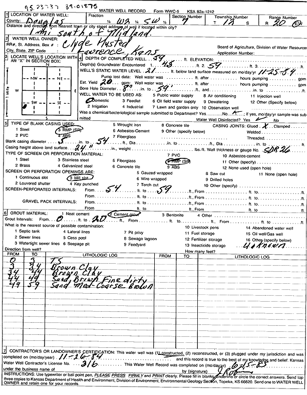
| Owner: Husted, Clyde | Status: Constructed | ||
| Location: T12S, R20E, Sec. 7, W2 SW | County: Douglas | ||
| Directions: from Midland: 1 mi S | |||
| Latitude: 39.0187499 | Longitude: -95.2396147 | Datum NAD 27 | |
| Latitude: 39.0187512 | Longitude: -95.2398647 | Datum NAD 83 | |
| Longitude and latitude calculated by Survey from township-range-section-quarter calls. Only good to within the quarter call accuracy. | |||
| View well on interactive map | |||
| General Info | ||
| Well Depth: 59 ft. | Elevation: ft. | |
| Static Water Level: 21 ft. | Est. Yield: 20 gpm. | |
| Comp. Date: 26-Nov-1984 | Well Use: Domestic | |
| DWR Applic. #: | Other ID: | |
| Driller Info | ||
| Driller: Jack W. Robison Well Drilling | License #: 316 | |
| Scanned Form | View scan |
|
Chemical Sample Submitted?: No
Water Well disinfected?: | ||
| Ground water encountered: 45 ft. , 59 ft. , 0 ft. | ||
| Pump test data: Well water was 0 ft after 0 hours pumping 0 gpm | ||
| Casing Info | ||
| Casing Type: RMP(SR)
Casing Joints: |
Diam: 5 in. to 54 ft
Diam: 0 in. to 0 ft Diam: 0 in. to 0 ft | |
| Casing height above land surface: in
Casing Weight: lbs/ft Wall thickness or gauge no.: | ||
| Screen and Perforation Info | ||
| Screen Type: RMP (SR) | Screen Openings: Mill slot | |
| Screen-perforated intervals | From: 54 ft to 59 ft
From: 0 ft to 0 ft From: 0 ft to 0 ft | |
| Gravel pack intervals | From: ft to ft | |
| Grout Info | ||
| Grout used: Cement grout | From: 0 to 20 ft
From: 0 to 0 ft From: 0 to 0 ft | |
| Source of Possible Contamination | ||
| Source: | ||
| Direction from well: | Distance: 0 ft | |
| Lithologic Log
(Log data entered by KGS.) | ||
| From: 0 ft. to 3 ft. | top soil | |
| From: 3 ft. to 34 ft. | brown clay | |
| From: 34 ft. to 44 ft. | brown clay | |
| From: 44 ft. to 49 ft. | fine sand, brown, dirty | |
| From: 49 ft. to 59 ft. | medium-coarse sand, brown | |