|
|
|
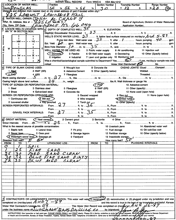
Specific Water Well Detail |
|
|
| Location Info | |||
| Owner: Chaney, John M. | Status: Constructed | ||
| Location: T12S, R20E, Sec. 30, SE SE SE | County: Douglas | ||
| Directions: 825 Locust, Lawrence | |||
| Latitude: 38.9725444 | Longitude: -95.2245143 | Datum NAD 27 | |
| Latitude: 38.9725466 | Longitude: -95.2247642 | Datum NAD 83 | |
| Longitude and latitude calculated by Survey from township-range-section-quarter calls. Only good to within the quarter call accuracy. | |||
| View well on interactive map | |||
| General Info | ||
| Well Depth: 35 ft. | Elevation: ft. | |
| Static Water Level: 23 ft. | Est. Yield: 60 gpm. | |
| Comp. Date: 07-Aug-1989 | Well Use: Domestic | |
| DWR Applic. #: | Other ID: | |
| Driller Info | ||
| Driller: Jungmann Bros Drilling Co. | License #: | |
| Scanned Form | View scan |
|
Chemical Sample Submitted?: No
Water Well disinfected?: | ||
| Ground water encountered: 23 ft. , 0 ft. , 0 ft. | ||
| Pump test data: Well water was 33 ft after 1 hours pumping 40 gpm | ||
| Casing Info | ||
| Casing Type: PVC
Casing Joints: |
Diam: 5 in. to 27 ft
Diam: 0 in. to 0 ft Diam: 0 in. to 0 ft | |
| Casing height above land surface: in
Casing Weight: lbs/ft Wall thickness or gauge no.: | ||
| Screen and Perforation Info | ||
| Screen Type: PVC | Screen Openings: Mill slot | |
| Screen-perforated intervals | From: 27 ft to 35 ft
From: 0 ft to 0 ft From: 0 ft to 0 ft | |
| Gravel pack intervals | From: ft to ft | |
| Grout Info | ||
| Grout used: Neat cement | From: 0 to 25 ft
From: 0 to 0 ft From: 0 to 0 ft | |
| Source of Possible Contamination | ||
| Source: Watertight sewer lines | ||
| Direction from well: | Distance: 0 ft | |
| Lithologic Log
(Log data entered by KGS.) | ||
| From: 0 ft. to 1 ft. | soil | |
| From: 1 ft. to 25 ft. | fine sand | |
| From: 25 ft. to 30 ft. | medium sand, clean | |
| From: 30 ft. to 32 ft. | fine sand, dirty, blue | |
| From: 32 ft. to 35 ft. | medium sand, clean, blue | |