|
|
|
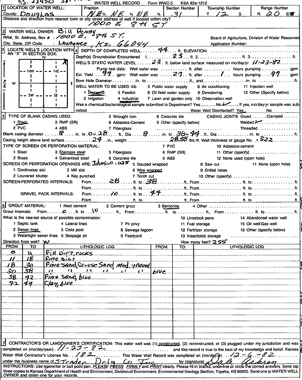
Specific Water Well Detail |
|
|
| Location Info | |||
| Owner: Penny, Bill | Status: Constructed | ||
| Location: T12S, R20E, Sec. 31, NE NE NE | County: Douglas | ||
| Directions: 1000 E 8th St, Lawrence | |||
| Latitude: 38.9707203 | Longitude: -95.2245024 | Datum NAD 27 | |
| Latitude: 38.9707226 | Longitude: -95.2247523 | Datum NAD 83 | |
| Longitude and latitude calculated by Survey from township-range-section-quarter calls. Only good to within the quarter call accuracy. | |||
| View well on interactive map | |||
| General Info | ||
| Well Depth: 44 ft. | Elevation: ft. | |
| Static Water Level: 23 ft. | Est. Yield: 97 gpm. | |
| Comp. Date: 23-Nov-1982 | Well Use: Industrial | |
| DWR Applic. #: | Other ID: | |
| Links | |
| No Wizard information available. | |
| View info from WIMAS Water Right Data base... | |
| Driller Info | ||
| Driller: Strader Drilling Co., Inc. | License #: 182 | |
| Scanned Form | View scan |
|
Chemical Sample Submitted?: No
Water Well disinfected?: | ||
| Ground water encountered: 0 ft. , 0 ft. , 0 ft. | ||
| Pump test data: Well water was 0 ft after 0 hours pumping 0 gpm | ||
| Casing Info | ||
| Casing Type:
Casing Joints: |
Diam: 0 in. to 0 ft
Diam: 0 in. to 0 ft Diam: 0 in. to 0 ft | |
| Casing height above land surface: in
Casing Weight: lbs/ft Wall thickness or gauge no.: | ||
| Screen and Perforation Info | ||
| Screen Type: | Screen Openings: | |
| Screen-perforated intervals | From: 28 ft to 38 ft
From: 0 ft to 0 ft From: 0 ft to 0 ft | |
| Gravel pack intervals | From: ft to ft | |
| Grout Info | ||
| Grout used: | From: 0 to 0 ft
From: 0 to 0 ft From: 0 to 0 ft | |
| Source of Possible Contamination | ||
| Source: | ||
| Direction from well: | Distance: 0 ft | |
| Lithologic Log
(Log data entered by KGS.) | ||
| From: 0 ft. to 11 ft. | fill dirt, rocks | |
| From: 11 ft. to 18 ft. | fine silt | |
| From: 18 ft. to 30 ft. | fine sand, coarse sand, and medium gravel | |
| From: 30 ft. to 38 ft. | fine sand, coarse sand, and medium gravel, blue | |
| From: 38 ft. to 42 ft. | fine sand, blue | |
| From: 42 ft. to 44 ft. | clay, blue | |