|
|
|
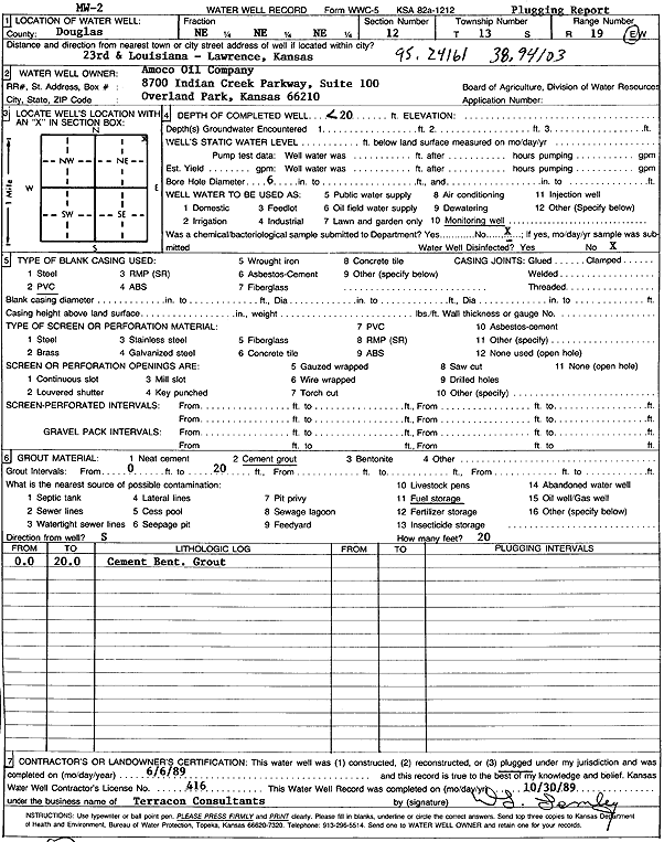
Specific Water Well Detail |
|
|
| Location Info | |||
| Owner: Amoco Oil Co. | Status: Plugged | ||
| Location: T13S, R19E, Sec. 12, NE NE NE | County: Douglas | ||
| Directions: 23rd and Louisiana, Lawrence | |||
| Latitude: 38.9419373 | Longitude: -95.2427706 | Datum NAD 27 | |
| Latitude: 38.9419401 | Longitude: -95.2430209 | Datum NAD 83 | |
| Longitude and latitude calculated by Survey from township-range-section-quarter calls. Only good to within the quarter call accuracy. | |||
| View well on interactive map | |||
| General Info | ||
| Well Depth: 20 ft. | Elevation: ft. | |
| Static Water Level: ft. | Est. Yield: gpm. | |
| Comp. Date: 06-Jun-1989 | Well Use: Monitoring well/observation/piezometer | |
| DWR Applic. #: | Other ID: MW 2 | |
| Driller Info | ||
| Driller: Terracon, Inc. | License #: 416 | |
| Scanned Form | View scan |
| Casing Info | ||
|
Casing Type: PVC
Diam: 0 in. Casing height above land surface: in | ||
| Grout Info | ||
| Grout used: Cement grout | From: 0 to 20 ft
From: 0 to 0 ft From: 0 to 0 ft | |
| Source of Possible Contamination | ||
| Source: Fuel storage | ||
| Direction from well: | Distance: 0 ft | |