|
|
|
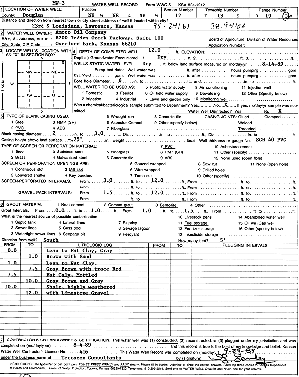
Specific Water Well Detail |
|
|
| Location Info | |||
| Owner: Amoco Oil Co. | Status: Constructed | ||
| Location: T13S, R19E, Sec. 12, NE NE NE | County: Douglas | ||
| Directions: 23rd and Louisiana, Lawrence | |||
| Latitude: 38.9419373 | Longitude: -95.2427706 | Datum NAD 27 | |
| Latitude: 38.9419401 | Longitude: -95.2430209 | Datum NAD 83 | |
| Longitude and latitude calculated by Survey from township-range-section-quarter calls. Only good to within the quarter call accuracy. | |||
| View well on interactive map | |||
| General Info | ||
| Well Depth: 12 ft. | Elevation: ft. | |
| Static Water Level: ft. | Est. Yield: gpm. | |
| Comp. Date: 04-Aug-1989 | Well Use: Monitoring well/observation/piezometer | |
| DWR Applic. #: | Other ID: MW 3 | |
| Driller Info | ||
| Driller: Terracon, Inc. | License #: 416 | |
| Scanned Form | View scan |
|
Chemical Sample Submitted?: No
Water Well disinfected?: | ||
| Ground water encountered: 0 ft. , 0 ft. , 0 ft. | ||
| Pump test data: Well water was 0 ft after 0 hours pumping 0 gpm | ||
| Casing Info | ||
| Casing Type: PVC
Casing Joints: |
Diam: 2 in. to 0 ft
Diam: 0 in. to 0 ft Diam: 0 in. to 0 ft | |
| Casing height above land surface: in
Casing Weight: lbs/ft Wall thickness or gauge no.: | ||
| Screen and Perforation Info | ||
| Screen Type: PVC | Screen Openings: Mill slot | |
| Screen-perforated intervals | From: 3 ft to 12 ft
From: 0 ft to 0 ft From: 0 ft to 0 ft | |
| Gravel pack intervals | From: ft to ft | |
| Grout Info | ||
| Grout used: Cement grout, Bentonite | From: 0 to 1 ft
From: 1 to 2 ft From: 0 to 0 ft | |
| Source of Possible Contamination | ||
| Source: Fuel storage | ||
| Direction from well: | Distance: 0 ft | |
| Lithologic Log
(Log data entered by KGS.) | ||
| From: 0 ft. to 1 ft. | lean to fat clay, gray brown, with sand | |
| From: 1 ft. to 7.5 ft. | lean to fat clay, gray brown, with trace red | |
| From: 7.5 ft. to 10 ft. | fat clay, mottled gray brown and gray | |
| From: 10 ft. to 12 ft. | shale, highly weathered, with limestone gravel | |