|
|
|
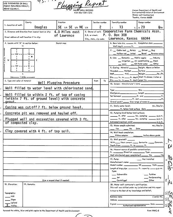
Specific Water Well Detail |
|
|
| Location Info | |||
| Owner: Cooperative Farm Chemicals Assoc. | Status: Plugged | ||
| Location: T13S, R20E, Sec. 2, SE SE NE | County: Douglas | ||
| Directions: from Lawrence: 4 mi E | |||
| Latitude: 38.9505825 | Longitude: -95.1497694 | Datum NAD 27 | |
| Latitude: 38.9505859 | Longitude: -95.150018 | Datum NAD 83 | |
| Longitude and latitude calculated by Survey from township-range-section-quarter calls. Only good to within the quarter call accuracy. | |||
| View well on interactive map | |||
| General Info | ||
| Well Depth: ft. | Elevation: ft. | |
| Static Water Level: ft. | Est. Yield: gpm. | |
| Comp. Date: 17-May-1979 | Well Use: (unstated)/abandoned | |
| DWR Applic. #: | Other ID: | |
| Driller Info | ||
| Driller: Cooperative Farm Chemicals Assn. | License #: | |
| Scanned Form | View scan |
| Casing Info | ||
|
Casing Type: PVC
Diam: 5 in. Casing height above land surface: in | ||
| Grout Info | ||
| Grout used: Neat cement | From: 3 to 6 ft
From: 0 to 0 ft From: 0 to 0 ft | |
| Source of Possible Contamination | ||
| Source: Fertilizer storage | ||
| Direction from well: | Distance: 0 ft | |