|
|
|
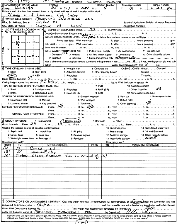
Specific Water Well Detail |
|
|
| Location Info | |||
| Owner: Farmland Industries, Inc. | Status: Plugged | ||
| Location: T13S, R20E, Sec. 4, NE SW NW | County: Douglas | ||
| Directions: from Lawrence: .25 mi E | |||
| Latitude: 38.9525406 | Longitude: -95.2011227 | Datum NAD 27 | |
| Latitude: 38.9525435 | Longitude: -95.2013722 | Datum NAD 83 | |
| Longitude and latitude calculated by Survey from township-range-section-quarter calls. Only good to within the quarter call accuracy. | |||
| View well on interactive map | |||
| General Info | ||
| Well Depth: 23 ft. | Elevation: ft. | |
| Static Water Level: ft. | Est. Yield: gpm. | |
| Comp. Date: 26-Mar-1992 | Well Use: Monitoring well/observation/piezometer | |
| DWR Applic. #: | Other ID: | |
| Driller Info | ||
| Driller: Farmland Industries, Inc. | License #: | |
| Scanned Form | View scan |
| Casing Info | ||
|
Casing Type: PVC
Diam: 4 in. Casing height above land surface: in | ||
| Grout Info | ||
| Grout used: Cement grout | From: 13 to 23 ft
From: 0 to 0 ft From: 0 to 0 ft | |
| Source of Possible Contamination | ||
| Source: OTHER | ||
| Direction from well: | Distance: 0 ft | |