|
|
|
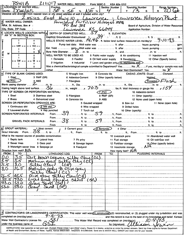
Specific Water Well Detail |
|
|
| Location Info | |||
| Owner: Farmland Fertilizer Nitrogen Mfg. | Status: Constructed | ||
| Location: T13S, R20E, Sec. 4, SE SE NE | County: Douglas | ||
| Directions: Lawrence Nitrogen Plant - from Lawrence: 2 mi E on K-10 | |||
| Latitude: 38.950697 | Longitude: -95.1870823 | Datum NAD 27 | |
| Latitude: 38.9507 | Longitude: -95.1873316 | Datum NAD 83 | |
| Longitude and latitude calculated by Survey from township-range-section-quarter calls. Only good to within the quarter call accuracy. | |||
| View well on interactive map | |||
| General Info | ||
| Well Depth: 59 ft. | Elevation: ft. | |
| Static Water Level: 14.46 ft. | Est. Yield: gpm. | |
| Comp. Date: 10-Sep-1993 | Well Use: Monitoring well/observation/piezometer | |
| DWR Applic. #: 2111017 | Other ID: PSW 1 B | |
| Driller Info | ||
| Driller: Geotechnical Services, Inc. | License #: 531 | |
| Scanned Form | View scan |
|
Chemical Sample Submitted?: No
Water Well disinfected?: | ||
| Ground water encountered: 0 ft. , 39 ft. , 0 ft. | ||
| Pump test data: Well water was 0 ft after 0 hours pumping 0 gpm | ||
| Casing Info | ||
| Casing Type: PVC
Casing Joints: |
Diam: 2 in. to 0 ft
Diam: 0 in. to 0 ft Diam: 0 in. to 0 ft | |
| Casing height above land surface: in
Casing Weight: lbs/ft Wall thickness or gauge no.: | ||
| Screen and Perforation Info | ||
| Screen Type: PVC | Screen Openings: Mill slot | |
| Screen-perforated intervals | From: 39 ft to 59 ft
From: 0 ft to 0 ft From: 0 ft to 0 ft | |
| Gravel pack intervals | From: ft to ft | |
| Grout Info | ||
| Grout used: Bentonite | From: 1 to 38 ft
From: 0 to 0 ft From: 0 to 0 ft | |
| Source of Possible Contamination | ||
| Source: OTHER | ||
| Direction from well: | Distance: 0 ft | |
| Lithologic Log
(Log data entered by KGS.) | ||
| From: 0 ft. to 3.5 ft. | dark brown organic silty clay | |
| From: 3.5 ft. to 5.5 ft. | medium gray silty clay | |
| From: 5.5 ft. to 8 ft. | silty clay | |
| From: 8 ft. to 26.5 ft. | medium gray to olive gray silty clay | |
| From: 26.5 ft. to 35.5 ft. | olive gray silty clay | |
| From: 35.5 ft. to 43 ft. | light gray clayey sand | |
| From: 43 ft. to 53 ft. | gray sand | |
| From: 53 ft. to 59 ft. | gray sand | |