|
|
|
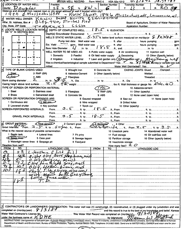
Specific Water Well Detail |
|
|
| Location Info | |||
| Owner: Kansas Dept. of Health and Environment | Status: Constructed | ||
| Location: T13S, R20E, Sec. 6, SE SE NW | County: Douglas | ||
| Directions: Kwik Shop, 1846 Massachusetts, Lawrence | |||
| Latitude: 38.9507862 | Longitude: -95.2335672 | Datum NAD 27 | |
| Latitude: 38.9507889 | Longitude: -95.2338174 | Datum NAD 83 | |
| Longitude and latitude calculated by Survey from township-range-section-quarter calls. Only good to within the quarter call accuracy. | |||
| View well on interactive map | |||
| General Info | ||
| Well Depth: 18.5 ft. | Elevation: ft. | |
| Static Water Level: 5.35 ft. | Est. Yield: gpm. | |
| Comp. Date: 03-Aug-1988 | Well Use: Monitoring well/observation/piezometer | |
| DWR Applic. #: | Other ID: | |
| Driller Info | ||
| Driller: KDHE | License #: | |
| Scanned Form | View scan |
|
Chemical Sample Submitted?: Yes
Water Well disinfected?: | ||
| Ground water encountered: 0 ft. , 0 ft. , 0 ft. | ||
| Pump test data: Well water was 0 ft after 0 hours pumping 0 gpm | ||
| Casing Info | ||
| Casing Type: PVC
Casing Joints: |
Diam: 2 in. to 3 ft
Diam: 0 in. to 0 ft Diam: 0 in. to 0 ft | |
| Casing height above land surface: in
Casing Weight: lbs/ft Wall thickness or gauge no.: | ||
| Screen and Perforation Info | ||
| Screen Type: PVC | Screen Openings: Mill slot | |
| Screen-perforated intervals | From: 3 ft to 18 ft
From: 0 ft to 0 ft From: 0 ft to 0 ft | |
| Gravel pack intervals | From: ft to ft | |
| Grout Info | ||
| Grout used: Neat cement, Bentonite | From: 0 to 2 ft
From: 2 to 3 ft From: 0 to 0 ft | |
| Source of Possible Contamination | ||
| Source: Sewer lines | ||
| Direction from well: | Distance: 0 ft | |
| Lithologic Log
(Log data entered by KGS.) | ||
| From: 0 ft. to 2.3 ft. | limestone and silt fill | |
| From: 2.3 ft. to 4.3 ft. | silty clay, dark gray-brown, moist | |
| From: 4.3 ft. to 5 ft. | clay, dark gray, moist | |
| From: 5 ft. to 7.6 ft. | clay, tan to light gray, moist | |
| From: 7.6 ft. to 10.4 ft. | clay, yellow brown, moist | |
| From: 10.4 ft. to 18.4 ft. | shale, silty, clayey, micaceous, with moist beds, gray stains | |