|
|
|
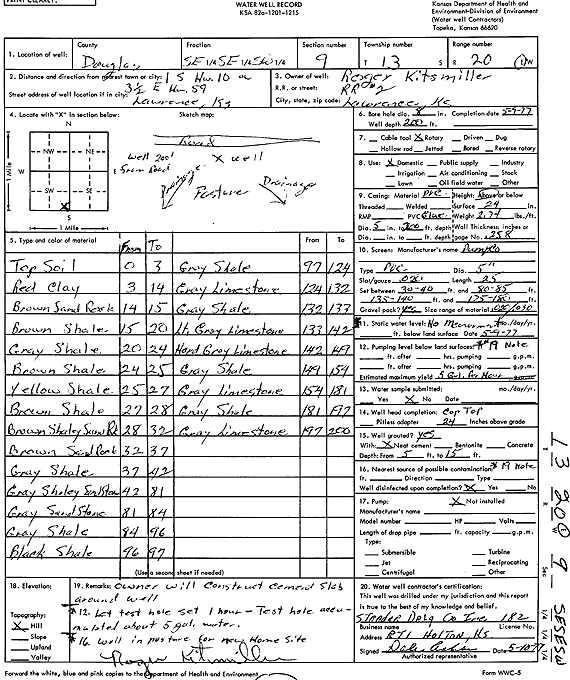
Specific Water Well Detail |
|
|
| Location Info | |||
| Owner: Kitsmiller, Roger | Status: Constructed | ||
| Location: T13S, R20E, Sec. 9, SE SE SW | County: Douglas | ||
| Directions: from Hwy 10: 1 mi S, 3.5 mi E of Hwy 59 | |||
| Latitude: 38.9290678 | Longitude: -95.1963997 | Datum NAD 27 | |
| Latitude: 38.9290713 | Longitude: -95.1966491 | Datum NAD 83 | |
| Longitude and latitude calculated by Survey from township-range-section-quarter calls. Only good to within the quarter call accuracy. | |||
| View well on interactive map | |||
| General Info | ||
| Well Depth: 200 ft. | Elevation: ft. | |
| Static Water Level: ft. | Est. Yield: .08 gpm. | |
| Comp. Date: 09-May-1977 | Well Use: Domestic | |
| DWR Applic. #: | Other ID: | |
| Driller Info | ||
| Driller: Strader Drilling Co., Inc. | License #: 182 | |
| Scanned Form | View scan |
|
Chemical Sample Submitted?: No
Water Well disinfected?: | ||
| Ground water encountered: 0 ft. , 0 ft. , 0 ft. | ||
| Pump test data: Well water was 0 ft after 0 hours pumping 0 gpm | ||
| Casing Info | ||
| Casing Type:
Casing Joints: |
Diam: 0 in. to 0 ft
Diam: 0 in. to 0 ft Diam: 0 in. to 0 ft | |
| Casing height above land surface: in
Casing Weight: lbs/ft Wall thickness or gauge no.: | ||
| Screen and Perforation Info | ||
| Screen Type: | Screen Openings: | |
| Screen-perforated intervals | From: 30 ft to 40 ft
From: 80 ft to 85 ft From: 135 ft to 140 ft | |
| Gravel pack intervals | From: ft to ft | |
| Grout Info | ||
| Grout used: | From: 0 to 0 ft
From: 0 to 0 ft From: 0 to 0 ft | |
| Source of Possible Contamination | ||
| Source: | ||
| Direction from well: | Distance: 0 ft | |
| Lithologic Log
(Log data entered by KGS.) | ||
| From: 0 ft. to 3 ft. | top soil | |
| From: 3 ft. to 14 ft. | red clay | |
| From: 14 ft. to 15 ft. | brown sand rock | |
| From: 15 ft. to 20 ft. | brown shale | |
| From: 20 ft. to 24 ft. | gray shale | |
| From: 24 ft. to 25 ft. | brown shale | |
| From: 25 ft. to 27 ft. | yellow shale | |
| From: 27 ft. to 28 ft. | brown shale | |
| From: 28 ft. to 32 ft. | brown shaley sand rock | |
| From: 32 ft. to 37 ft. | brown sand rock | |
| From: 37 ft. to 42 ft. | gray shale | |
| From: 42 ft. to 81 ft. | gray shaley sandstone | |
| From: 81 ft. to 84 ft. | gray sandstone | |
| From: 84 ft. to 96 ft. | gray shale | |
| From: 96 ft. to 97 ft. | black shale | |
| From: 97 ft. to 124 ft. | gray shale | |
| From: 124 ft. to 132 ft. | gray limestone | |
| From: 132 ft. to 133 ft. | gray shale | |
| From: 133 ft. to 142 ft. | light gray limestone | |
| From: 142 ft. to 149 ft. | hard gray limestone | |
| From: 149 ft. to 154 ft. | gray shale | |
| From: 154 ft. to 181 ft. | gray limestone | |
| From: 181 ft. to 192 ft. | gray shale | |
| From: 192 ft. to 200 ft. | gray limestone | |