|
|
|
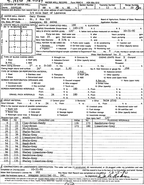
Specific Water Well Detail |
|
|
| Location Info | |||
| Owner: Thomas, Gary | Status: Constructed | ||
| Location: T13S, R20E, Sec. 9, NW NW NE | County: Douglas | ||
| Directions: from Lawrence: .75 mi E | |||
| Latitude: 38.9418123 | Longitude: -95.1940745 | Datum NAD 27 | |
| Latitude: 38.9418155 | Longitude: -95.194324 | Datum NAD 83 | |
| Longitude and latitude calculated by Survey from township-range-section-quarter calls. Only good to within the quarter call accuracy. | |||
| View well on interactive map | |||
| General Info | ||
| Well Depth: 180 ft. | Elevation: ft. | |
| Static Water Level: 120 ft. | Est. Yield: 15 gpm. | |
| Comp. Date: 31-Oct-1990 | Well Use: Domestic | |
| DWR Applic. #: | Other ID: | |
| Driller Info | ||
| Driller: Strader Drilling Co., Inc. | License #: 182 | |
| Scanned Form | View scan |
|
Chemical Sample Submitted?: No
Water Well disinfected?: | ||
| Ground water encountered: 170 ft. , 0 ft. , 0 ft. | ||
| Pump test data: Well water was 0 ft after 0 hours pumping 0 gpm | ||
| Casing Info | ||
| Casing Type: PVC
Casing Joints: |
Diam: 5 in. to 140 ft
Diam: 0 in. to 0 ft Diam: 0 in. to 0 ft | |
| Casing height above land surface: in
Casing Weight: lbs/ft Wall thickness or gauge no.: | ||
| Screen and Perforation Info | ||
| Screen Type: PVC | Screen Openings: Saw cut | |
| Screen-perforated intervals | From: 140 ft to 180 ft
From: 0 ft to 0 ft From: 0 ft to 0 ft | |
| Gravel pack intervals | From: ft to ft | |
| Grout Info | ||
| Grout used: | From: 4 to 24 ft
From: 0 to 0 ft From: 0 to 0 ft | |
| Source of Possible Contamination | ||
| Source: Septic Tank | ||
| Direction from well: | Distance: 0 ft | |
| Lithologic Log
(Log data entered by KGS.) | ||
| From: 0 ft. to 15 ft. | sandy clay, brown | |
| From: 15 ft. to 22 ft. | clay, brown | |
| From: 22 ft. to 25 ft. | fine and coarse sand, brown | |
| From: 25 ft. to 31 ft. | shale, yellow | |
| From: 31 ft. to 39 ft. | shale, gray | |
| From: 39 ft. to 43 ft. | limestone, gray | |
| From: 43 ft. to 54 ft. | shale, gray | |
| From: 54 ft. to 75 ft. | sand rock | |
| From: 75 ft. to 94 ft. | shale, gray | |
| From: 94 ft. to 96 ft. | limestone, gray | |
| From: 96 ft. to 105 ft. | shaley limestone, gray | |
| From: 105 ft. to 113 ft. | sandstone, gray | |
| From: 113 ft. to 115 ft. | shale, gray | |
| From: 115 ft. to 135 ft. | shaley limestone, gray | |
| From: 135 ft. to 173 ft. | sandstone, gray | |
| From: 173 ft. to 180 ft. | limestone, gray | |