|
|
|
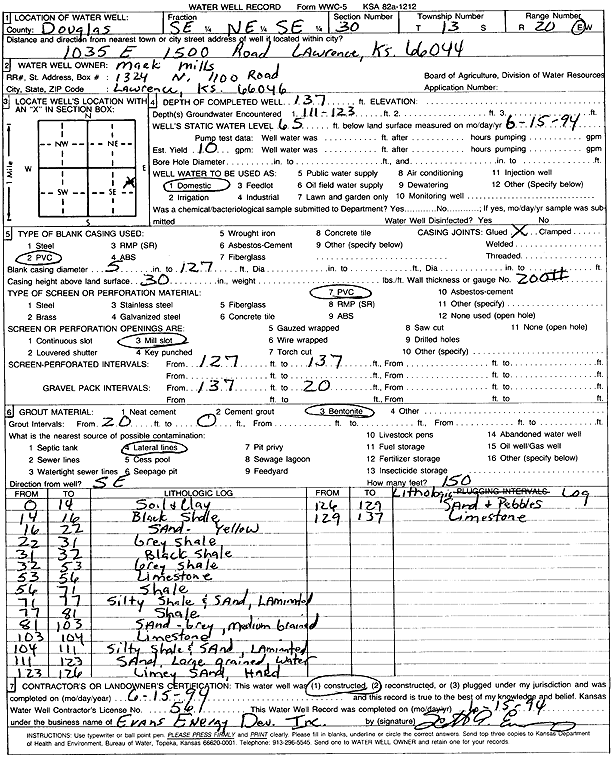
Specific Water Well Detail |
|
|
| Location Info | |||
| Owner: Mills, Mark | Status: Constructed | ||
| Location: T13S, R20E, Sec. 30, SE NE SE | County: Douglas | ||
| Directions: 1035 E 1500 Rd, Lawrence | |||
| Latitude: 38.8890882 | Longitude: -95.2247927 | Datum NAD 27 | |
| Latitude: 38.8890924 | Longitude: -95.2250428 | Datum NAD 83 | |
| Longitude and latitude calculated by Survey from township-range-section-quarter calls. Only good to within the quarter call accuracy. | |||
| View well on interactive map | |||
| General Info | ||
| Well Depth: 137 ft. | Elevation: ft. | |
| Static Water Level: 65 ft. | Est. Yield: 10 gpm. | |
| Comp. Date: 15-Jun-1994 | Well Use: Domestic | |
| DWR Applic. #: | Other ID: | |
| Driller Info | ||
| Driller: Evans Energy Development, Inc. | License #: 561 | |
| Scanned Form | View scan |
|
Chemical Sample Submitted?: No
Water Well disinfected?: | ||
| Ground water encountered: 111 ft. , 0 ft. , 0 ft. | ||
| Pump test data: Well water was 0 ft after 0 hours pumping 0 gpm | ||
| Casing Info | ||
| Casing Type: PVC
Casing Joints: |
Diam: 5 in. to 127 ft
Diam: 0 in. to 0 ft Diam: 0 in. to 0 ft | |
| Casing height above land surface: in
Casing Weight: lbs/ft Wall thickness or gauge no.: | ||
| Screen and Perforation Info | ||
| Screen Type: PVC | Screen Openings: Mill slot | |
| Screen-perforated intervals | From: 127 ft to 137 ft
From: 0 ft to 0 ft From: 0 ft to 0 ft | |
| Gravel pack intervals | From: ft to ft | |
| Grout Info | ||
| Grout used: Bentonite | From: 0 to 20 ft
From: 0 to 0 ft From: 0 to 0 ft | |
| Source of Possible Contamination | ||
| Source: Lateral lines | ||
| Direction from well: | Distance: 0 ft | |
| Lithologic Log
(Log data entered by KGS.) | ||
| From: 0 ft. to 14 ft. | soil and clay | |
| From: 14 ft. to 16 ft. | black shale | |
| From: 16 ft. to 22 ft. | sand, yellow | |
| From: 22 ft. to 31 ft. | gray shale | |
| From: 31 ft. to 32 ft. | black shale | |
| From: 32 ft. to 53 ft. | gray shale | |
| From: 53 ft. to 56 ft. | limestone | |
| From: 56 ft. to 71 ft. | shale | |
| From: 71 ft. to 77 ft. | silty shale and sand, laminated | |
| From: 77 ft. to 81 ft. | shale | |
| From: 81 ft. to 103 ft. | medium sand, gray | |
| From: 103 ft. to 104 ft. | limestone | |
| From: 104 ft. to 111 ft. | silty shale and sand, laminated | |
| From: 111 ft. to 123 ft. | large sand | |
| From: 123 ft. to 126 ft. | limey sand, hard | |
| From: 126 ft. to 129 ft. | sand and pebbles | |
| From: 129 ft. to 137 ft. | limestone | |