|
|
|
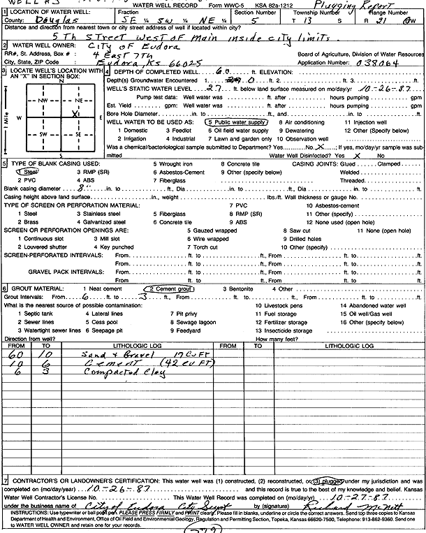
Specific Water Well Detail |
|
|
| Location Info | |||
| Owner: City of Eudora | Status: Plugged | ||
| Location: T13S, R21E, Sec. 5, SE SW NE | County: Douglas | ||
| Directions: 5th St W of Main | |||
| Latitude: 38.9505638 | Longitude: -95.0991457 | Datum NAD 27 | |
| Latitude: 38.9505675 | Longitude: -95.0993934 | Datum NAD 83 | |
| Longitude and latitude calculated by Survey from township-range-section-quarter calls. Only good to within the quarter call accuracy. | |||
| View well on interactive map | |||
| General Info | ||
| Well Depth: 60 ft. | Elevation: ft. | |
| Static Water Level: 27 ft. | Est. Yield: gpm. | |
| Comp. Date: 26-Oct-1987 | Well Use: Public Water Supply | |
| DWR Applic. #: 038064 | Other ID: Well 3 | |
| Links | |
| View info from Wizard Water Level Data base... | |
| View info from WIMAS Water Right Data base... | |
| Driller Info | ||
| Driller: City of Eudora | License #: | |
| Scanned Form | View scan |
| Casing Info | ||
|
Casing Type: Steel
Diam: 8 in. Casing height above land surface: in | ||
| Grout Info | ||
| Grout used: Cement grout | From: 6 to 3 ft
From: 0 to 0 ft From: 0 to 0 ft | |
| Source of Possible Contamination | ||
| Source: | ||
| Direction from well: | Distance: 0 ft | |