|
|
|
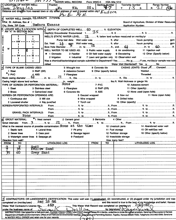
Specific Water Well Detail |
|
|
| Location Info | |||
| Owner: Brown, Richard | Status: Constructed | ||
| Location: T13S, R21E, Sec. 7, NW NW SE | County: Douglas | ||
| Directions: from Eudora: .5 mi E, .25 mi N | |||
| Latitude: 38.934177 | Longitude: -95.1196586 | Datum NAD 27 | |
| Latitude: 38.934181 | Longitude: -95.1199065 | Datum NAD 83 | |
| Longitude and latitude calculated by Survey from township-range-section-quarter calls. Only good to within the quarter call accuracy. | |||
| View well on interactive map | |||
| General Info | ||
| Well Depth: 60 ft. | Elevation: ft. | |
| Static Water Level: 31 ft. | Est. Yield: 1.5 gpm. | |
| Comp. Date: 18-Aug-1986 | Well Use: Domestic | |
| DWR Applic. #: | Other ID: | |
| Driller Info | ||
| Driller: Royce Swank Drilling | License #: 469 | |
| Scanned Form | View scan |
|
Chemical Sample Submitted?: No
Water Well disinfected?: | ||
| Ground water encountered: 35 ft. , 0 ft. , 0 ft. | ||
| Pump test data: Well water was 0 ft after 0 hours pumping 0 gpm | ||
| Casing Info | ||
| Casing Type: Steel
Casing Joints: |
Diam: 6 in. to 21 ft
Diam: 0 in. to 0 ft Diam: 0 in. to 0 ft | |
| Casing height above land surface: in
Casing Weight: lbs/ft Wall thickness or gauge no.: | ||
| Screen and Perforation Info | ||
| Screen Type: | Screen Openings: | |
| Screen-perforated intervals | From: 0 ft to 0 ft
From: 0 ft to 0 ft From: 0 ft to 0 ft | |
| Gravel pack intervals | From: ft to ft | |
| Grout Info | ||
| Grout used: Neat cement | From: 3 to 21 ft
From: 0 to 0 ft From: 0 to 0 ft | |
| Source of Possible Contamination | ||
| Source: | ||
| Direction from well: | Distance: 0 ft | |
| Lithologic Log
(Log data entered by KGS.) | ||
| From: 0 ft. to 7 ft. | soil | |
| From: 7 ft. to 35 ft. | yellow sand | |
| From: 35 ft. to 60 ft. | gray sand | |