|
|
|
Specific Water Well Detail |
|
|
| Location Info | |||
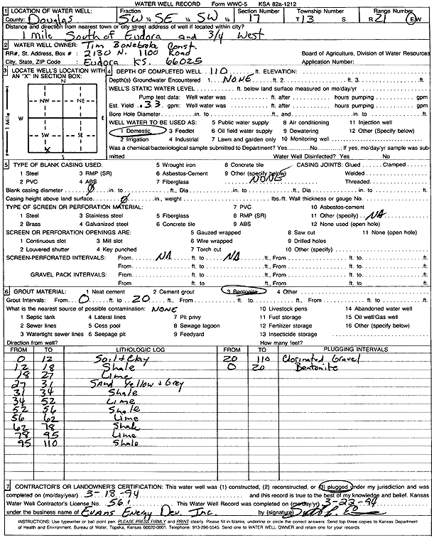
| Owner: Tim Bonebroke Construction | Status: Plugged | ||
| Location: T13S, R21E, Sec. 17, SW SE SW | County: Douglas | ||
| Directions: from Eudora: 1 mi S, .75 mi W | |||
| Latitude: 38.9141398 | Longitude: -95.1058913 | Datum NAD 27 | |
| Latitude: 38.9141442 | Longitude: -95.1061389 | Datum NAD 83 | |
| Longitude and latitude calculated by Survey from township-range-section-quarter calls. Only good to within the quarter call accuracy. | |||
| View well on interactive map | |||
| General Info | ||
| Well Depth: 110 ft. | Elevation: ft. | |
| Static Water Level: ft. | Est. Yield: .33 gpm. | |
| Comp. Date: 18-Mar-1994 | Well Use: Domestic | |
| DWR Applic. #: | Other ID: | |
| Driller Info | ||
| Driller: Evans Energy Development, Inc. | License #: 561 | |
| Scanned Form | View scan |
| Casing Info | ||
|
Casing Type: OTHER
Diam: 0 in. Casing height above land surface: in | ||
| Grout Info | ||
| Grout used: Bentonite | From: 0 to 20 ft
From: 0 to 0 ft From: 0 to 0 ft | |
| Source of Possible Contamination | ||
| Source: OTHER | ||
| Direction from well: | Distance: 0 ft | |
| Lithologic Log
(Log data entered by KGS.) | ||
| From: 0 ft. to 12 ft. | soil and clay | |
| From: 12 ft. to 18 ft. | shale | |
| From: 18 ft. to 27 ft. | limestone | |
| From: 27 ft. to 31 ft. | sand, yellow and gray | |
| From: 31 ft. to 34 ft. | shale | |
| From: 34 ft. to 52 ft. | limestone | |
| From: 52 ft. to 56 ft. | shale | |
| From: 56 ft. to 62 ft. | limestone | |
| From: 62 ft. to 78 ft. | shale | |
| From: 78 ft. to 95 ft. | limestone | |
| From: 95 ft. to 110 ft. | shale | |