|
|
|
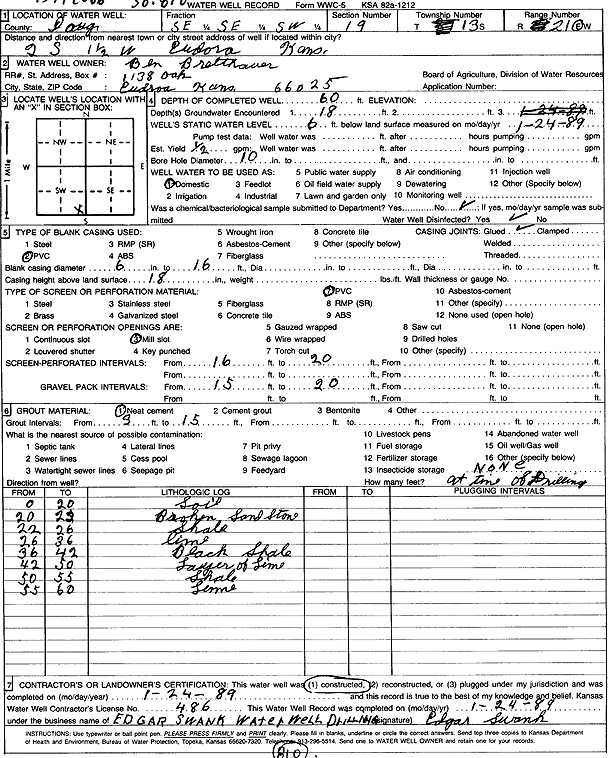
Specific Water Well Detail |
|
|
| Location Info | |||
| Owner: Bretthauer, Ben | Status: Constructed | ||
| Location: T13S, R21E, Sec. 19, SE SE SW | County: Douglas | ||
| Directions: from Eudora: 2 mi S, 1.5 mi W | |||
| Latitude: 38.899588 | Longitude: -95.1220182 | Datum NAD 27 | |
| Latitude: 38.8995927 | Longitude: -95.1222662 | Datum NAD 83 | |
| Longitude and latitude calculated by Survey from township-range-section-quarter calls. Only good to within the quarter call accuracy. | |||
| View well on interactive map | |||
| General Info | ||
| Well Depth: 60 ft. | Elevation: ft. | |
| Static Water Level: 6 ft. | Est. Yield: .5 gpm. | |
| Comp. Date: 24-Jan-1989 | Well Use: Domestic | |
| DWR Applic. #: | Other ID: | |
| Driller Info | ||
| Driller: Edgar Swank Drlg & Pump Repair | License #: 486 | |
| Scanned Form | View scan |
|
Chemical Sample Submitted?: No
Water Well disinfected?: | ||
| Ground water encountered: 16 ft. , 0 ft. , 0 ft. | ||
| Pump test data: Well water was 0 ft after 0 hours pumping 0 gpm | ||
| Casing Info | ||
| Casing Type: PVC
Casing Joints: |
Diam: 6 in. to 16 ft
Diam: 0 in. to 0 ft Diam: 0 in. to 0 ft | |
| Casing height above land surface: in
Casing Weight: lbs/ft Wall thickness or gauge no.: | ||
| Screen and Perforation Info | ||
| Screen Type: PVC | Screen Openings: Mill slot | |
| Screen-perforated intervals | From: 16 ft to 20 ft
From: 0 ft to 0 ft From: 0 ft to 0 ft | |
| Gravel pack intervals | From: ft to ft | |
| Grout Info | ||
| Grout used: Neat cement | From: 0 to 16 ft
From: 0 to 0 ft From: 0 to 0 ft | |
| Source of Possible Contamination | ||
| Source: OTHER | ||
| Direction from well: | Distance: 0 ft | |
| Lithologic Log
(Log data entered by KGS.) | ||
| From: 0 ft. to 20 ft. | soil | |
| From: 20 ft. to 22 ft. | broken sandstone | |
| From: 22 ft. to 26 ft. | shale | |
| From: 26 ft. to 36 ft. | limestone | |
| From: 36 ft. to 42 ft. | black shale | |
| From: 42 ft. to 50 ft. | layer of limestone | |
| From: 50 ft. to 55 ft. | shale | |
| From: 55 ft. to 60 ft. | limestone | |