|
|
|
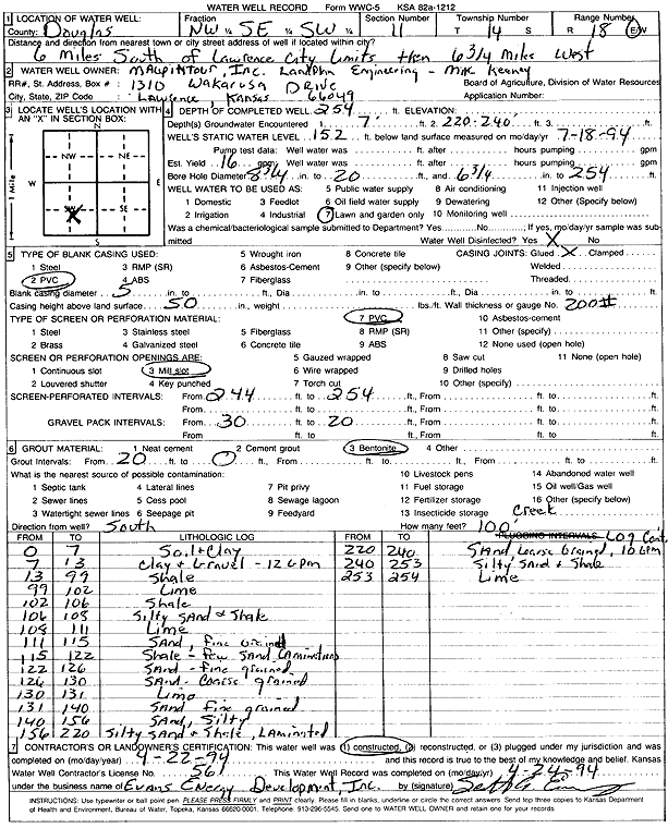
Specific Water Well Detail |
|
|
| Location Info | |||
| Owner: Maupintour Inc. | Status: Constructed | ||
| Location: T14S, R18E, Sec. 11, NW SE SW | County: Douglas | ||
| Directions: from Lawrence: 6 mi S, 6.75 mi W | |||
| Latitude: 38.8434435 | Longitude: -95.3845385 | Datum NAD 27 | |
| Latitude: 38.843448 | Longitude: -95.3847922 | Datum NAD 83 | |
| Longitude and latitude calculated by Survey from township-range-section-quarter calls. Only good to within the quarter call accuracy. | |||
| View well on interactive map | |||
| General Info | ||
| Well Depth: 254 ft. | Elevation: ft. | |
| Static Water Level: 152 ft. | Est. Yield: 16 gpm. | |
| Comp. Date: 22-Apr-1994 | Well Use: Domestic, Lawn and Garden | |
| DWR Applic. #: | Other ID: | |
| Driller Info | ||
| Driller: Evans Energy Development, Inc. | License #: 561 | |
| Scanned Form | View scan |
|
Chemical Sample Submitted?: No
Water Well disinfected?: | ||
| Ground water encountered: 7 ft. , 0 ft. , 0 ft. | ||
| Pump test data: Well water was 0 ft after 0 hours pumping 0 gpm | ||
| Casing Info | ||
| Casing Type: PVC
Casing Joints: |
Diam: 5 in. to 0 ft
Diam: 0 in. to 0 ft Diam: 0 in. to 0 ft | |
| Casing height above land surface: in
Casing Weight: lbs/ft Wall thickness or gauge no.: | ||
| Screen and Perforation Info | ||
| Screen Type: PVC | Screen Openings: Mill slot | |
| Screen-perforated intervals | From: 244 ft to 254 ft
From: 0 ft to 0 ft From: 0 ft to 0 ft | |
| Gravel pack intervals | From: ft to ft | |
| Grout Info | ||
| Grout used: Bentonite | From: 0 to 20 ft
From: 0 to 0 ft From: 0 to 0 ft | |
| Source of Possible Contamination | ||
| Source: OTHER | ||
| Direction from well: | Distance: 0 ft | |
| Lithologic Log
(Log data entered by KGS.) | ||
| From: 0 ft. to 7 ft. | Soil and clay | |
| From: 7 ft. to 13 ft. | Clay and gravel | |
| From: 13 ft. to 99 ft. | Shale | |
| From: 99 ft. to 102 ft. | Lime | |
| From: 102 ft. to 106 ft. | Shale | |
| From: 106 ft. to 108 ft. | Silty sand and shale | |
| From: 108 ft. to 111 ft. | Lime | |
| From: 111 ft. to 115 ft. | Sand, fine grained | |
| From: 115 ft. to 122 ft. | Shale, few sand laminations | |
| From: 122 ft. to 126 ft. | Sand, fine grained | |
| From: 126 ft. to 130 ft. | Sand, coarse grained | |
| From: 130 ft. to 131 ft. | Lime | |
| From: 131 ft. to 140 ft. | Sand, fine grained | |
| From: 140 ft. to 156 ft. | Sand, silty | |
| From: 156 ft. to 220 ft. | Silty sand and shale, laminated | |
| From: 220 ft. to 240 ft. | Sand, coarse grained | |
| From: 240 ft. to 253 ft. | Silty sand and shale | |
| From: 253 ft. to 254 ft. | Lime | |