|
|
|
Specific Water Well Detail |
|
|
| Location Info | |||
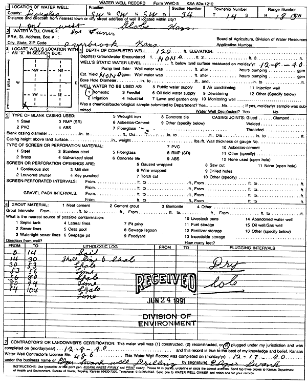
| Owner: Vuner, Joe | Status: Plugged | ||
| Location: T14S, R18E, Sec. 34, SW SW SW | County: Douglas | ||
| Directions: from Globe: 1 mi W | |||
| Latitude: 38.7833817 | Longitude: -95.4075808 | Datum NAD 27 | |
| Latitude: 38.7833874 | Longitude: -95.4078355 | Datum NAD 83 | |
| Longitude and latitude calculated by Survey from township-range-section-quarter calls. Only good to within the quarter call accuracy. | |||
| View well on interactive map | |||
| General Info | ||
| Well Depth: 120 ft. | Elevation: ft. | |
| Static Water Level: ft. | Est. Yield: gpm. | |
| Comp. Date: 08-Dec-1990 | Well Use: Domestic | |
| DWR Applic. #: | Other ID: | |
| Driller Info | ||
| Driller: Edgar Swank Drlg & Pump Repair | License #: 486 | |
| Scanned Form | View scan |
| Casing Info | ||
|
Casing Type: OTHER
Diam: 0 in. Casing height above land surface: in | ||
| Grout Info | ||
| Grout used: Bentonite | From: 3 to 104 ft
From: 0 to 0 ft From: 0 to 0 ft | |
| Source of Possible Contamination | ||
| Source: OTHER | ||
| Direction from well: | Distance: 0 ft | |
| Lithologic Log
(Log data entered by KGS.) | ||
| From: 0 ft. to 14 ft. | soil | |
| From: 14 ft. to 30 ft. | shell limestone and shale | |
| From: 30 ft. to 53 ft. | shale | |
| From: 53 ft. to 56 ft. | limestone | |
| From: 56 ft. to 80 ft. | shale | |
| From: 80 ft. to 94 ft. | limestone | |
| From: 94 ft. to 104 ft. | shale | |
| From: 104 ft. to 120 ft. | limestone | |