|
|
|
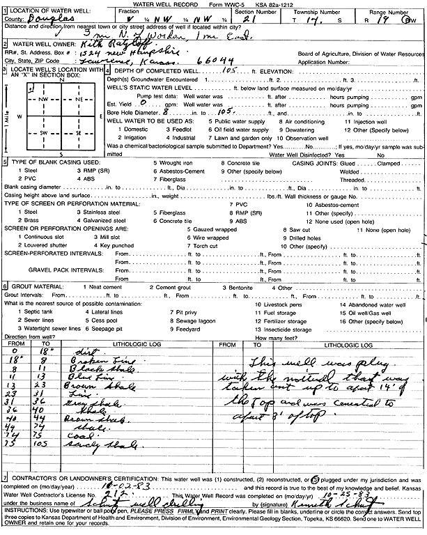
Specific Water Well Detail |
|
|
| Location Info | |||
| Owner: Ratzloff, Kith | Status: Plugged | ||
| Location: T14S, R19E, Sec. 21, W2 NW NW | County: Douglas | ||
| Directions: from Worden: 3 mi N, 1 mi E | |||
| Latitude: 38.8242278 | Longitude: -95.314982 | Datum NAD 27 | |
| Latitude: 38.8242331 | Longitude: -95.3152342 | Datum NAD 83 | |
| Longitude and latitude calculated by Survey from township-range-section-quarter calls. Only good to within the quarter call accuracy. | |||
| View well on interactive map | |||
| General Info | ||
| Well Depth: 105 ft. | Elevation: ft. | |
| Static Water Level: ft. | Est. Yield: gpm. | |
| Comp. Date: 02-Nov-1983 | Well Use: (unstated)/abandoned | |
| DWR Applic. #: | Other ID: | |
| Driller Info | ||
| Driller: Kenneth Schutz Drilling | License #: 212 | |
| Scanned Form | View scan |
| Casing Info | ||
|
Casing Type:
Diam: 0 in. Casing height above land surface: in | ||
| Grout Info | ||
| Grout used: | From: 0 to 0 ft
From: 0 to 0 ft From: 0 to 0 ft | |
| Source of Possible Contamination | ||
| Source: | ||
| Direction from well: | Distance: 0 ft | |
| Lithologic Log
(Log data entered by KGS.) | ||
| From: 0 ft. to 1.5 ft. | dirt | |
| From: 1.5 ft. to 8 ft. | broken limestone | |
| From: 8 ft. to 11 ft. | black shale | |
| From: 11 ft. to 13 ft. | blue limestone | |
| From: 13 ft. to 23 ft. | brown shale | |
| From: 23 ft. to 31 ft. | limestone | |
| From: 31 ft. to 36 ft. | gray shale | |
| From: 36 ft. to 40 ft. | shale | |
| From: 40 ft. to 44 ft. | brown shale | |
| From: 44 ft. to 74 ft. | shale | |
| From: 74 ft. to 75 ft. | coal | |
| From: 75 ft. to 105 ft. | sandy shale | |