|
|
|
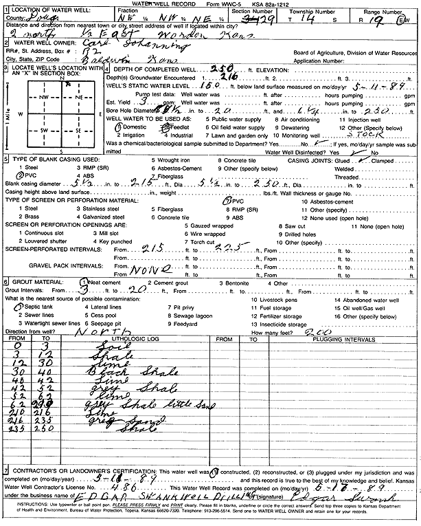
Specific Water Well Detail |
|
|
| Location Info | |||
| Owner: Johanning, Carl | Status: Constructed | ||
| Location: T14S, R19E, Sec. 29, NW NW NE | County: Douglas | ||
| Directions: from Worden: 2 mi N, .5 mi E | |||
| Latitude: 38.8106008 | Longitude: -95.3242498 | Datum NAD 27 | |
| Latitude: 38.8106063 | Longitude: -95.3245023 | Datum NAD 83 | |
| Longitude and latitude calculated by Survey from township-range-section-quarter calls. Only good to within the quarter call accuracy. | |||
| View well on interactive map | |||
| General Info | ||
| Well Depth: 250 ft. | Elevation: ft. | |
| Static Water Level: 150 ft. | Est. Yield: 3 gpm. | |
| Comp. Date: 11-May-1989 | Well Use: Domestic | |
| DWR Applic. #: | Other ID: | |
| Driller Info | ||
| Driller: Edgar Swank Drlg & Pump Repair | License #: 486 | |
| Scanned Form | View scan |
|
Chemical Sample Submitted?: No
Water Well disinfected?: | ||
| Ground water encountered: 216 ft. , 0 ft. , 0 ft. | ||
| Pump test data: Well water was 0 ft after 0 hours pumping 0 gpm | ||
| Casing Info | ||
| Casing Type: PVC
Casing Joints: |
Diam: 5 in. to 215 ft
Diam: 5 in. to 250 ft Diam: 0 in. to 0 ft | |
| Casing height above land surface: in
Casing Weight: lbs/ft Wall thickness or gauge no.: | ||
| Screen and Perforation Info | ||
| Screen Type: PVC | Screen Openings: | |
| Screen-perforated intervals | From: 215 ft to 225 ft
From: 0 ft to 0 ft From: 0 ft to 0 ft | |
| Gravel pack intervals | From: ft to ft | |
| Grout Info | ||
| Grout used: Neat cement | From: 3 to 20 ft
From: 0 to 0 ft From: 0 to 0 ft | |
| Source of Possible Contamination | ||
| Source: Septic Tank | ||
| Direction from well: | Distance: 0 ft | |
| Lithologic Log
(Log data entered by KGS.) | ||
| From: 0 ft. to 3 ft. | soil | |
| From: 3 ft. to 12 ft. | shale | |
| From: 12 ft. to 30 ft. | limestone | |
| From: 30 ft. to 40 ft. | black shale | |
| From: 40 ft. to 42 ft. | limestone | |
| From: 42 ft. to 52 ft. | gray shale | |
| From: 52 ft. to 62 ft. | limestone | |
| From: 62 ft. to 210 ft. | gray shale with little sand | |
| From: 210 ft. to 216 ft. | limestone | |
| From: 216 ft. to 235 ft. | gray sand | |
| From: 235 ft. to 250 ft. | shale | |