|
|
|
Specific Water Well Detail |
|
|
| Location Info | |||
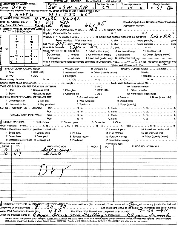
| Owner: Baugh, Mitchel | Status: Plugged | ||
| Location: T14S, R21E, Sec. 27, SW SW SW | County: Douglas | ||
| Directions: from US 56 and 33 Jct: 2 mi N | |||
| Latitude: 38.7977109 | Longitude: -95.0734385 | Datum NAD 27 | |
| Latitude: 38.797718 | Longitude: -95.0736849 | Datum NAD 83 | |
| Longitude and latitude calculated by Survey from township-range-section-quarter calls. Only good to within the quarter call accuracy. | |||
| View well on interactive map | |||
| General Info | ||
| Well Depth: 47 ft. | Elevation: ft. | |
| Static Water Level: ft. | Est. Yield: gpm. | |
| Comp. Date: 20-Jul-1990 | Well Use: Domestic | |
| DWR Applic. #: | Other ID: | |
| Driller Info | ||
| Driller: Edgar Swank Drlg & Pump Repair | License #: 486 | |
| Scanned Form | View scan |
| Casing Info | ||
|
Casing Type: OTHER
Diam: 0 in. Casing height above land surface: in | ||
| Grout Info | ||
| Grout used: | From: 0 to 20 ft
From: 0 to 0 ft From: 0 to 0 ft | |
| Source of Possible Contamination | ||
| Source: OTHER | ||
| Direction from well: | Distance: 0 ft | |
| Lithologic Log
(Log data entered by KGS.) | ||
| From: 0 ft. to 10 ft. | soil and clay | |
| From: 10 ft. to 47 ft. | shale | |