|
|
|
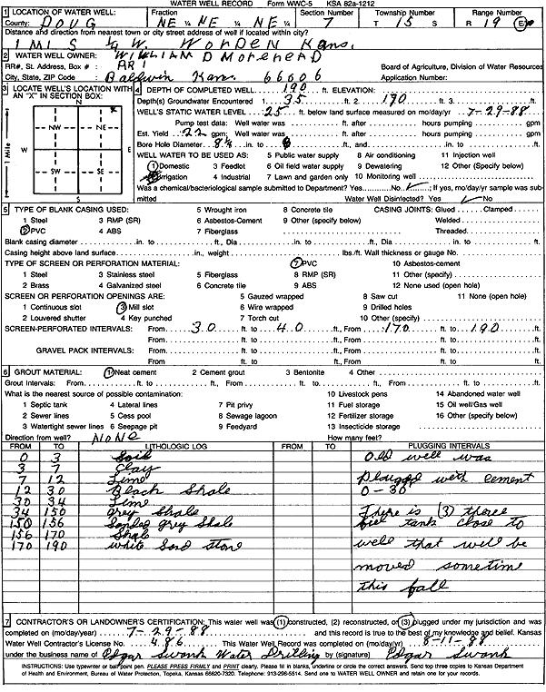
Specific Water Well Detail |
|
|
| Location Info | |||
| Owner: Morehead, William D. | Status: Plugged | ||
| Location: T15S, R19E, Sec. 7, NE NE NE | County: Douglas | ||
| Directions: from Worden: 1 mi S, .25 mi W | |||
| Latitude: 38.7668308 | Longitude: -95.3352034 | Datum NAD 27 | |
| Latitude: 38.7668373 | Longitude: -95.3354564 | Datum NAD 83 | |
| Longitude and latitude calculated by Survey from township-range-section-quarter calls. Only good to within the quarter call accuracy. | |||
| View well on interactive map | |||
| General Info | ||
| Well Depth: 30 ft. | Elevation: ft. | |
| Static Water Level: ft. | Est. Yield: gpm. | |
| Comp. Date: 29-Jul-1988 | Well Use: Domestic | |
| DWR Applic. #: | Other ID: | |
| Driller Info | ||
| Driller: Edgar Swank Drlg & Pump Repair | License #: 486 | |
| Scanned Form | View scan |
| Casing Info | ||
|
Casing Type: PVC
Diam: 0 in. Casing height above land surface: in | ||
| Grout Info | ||
| Grout used: Neat cement | From: 0 to 0 ft
From: 0 to 0 ft From: 0 to 0 ft | |
| Source of Possible Contamination | ||
| Source: | ||
| Direction from well: | Distance: 0 ft | |
| Lithologic Log
(Log data entered by KGS.) | ||
| From: 0 ft. to 3 ft. | soil | |
| From: 3 ft. to 7 ft. | clay | |
| From: 7 ft. to 12 ft. | limestone | |
| From: 12 ft. to 30 ft. | black shale | |
| From: 30 ft. to 34 ft. | limestone | |
| From: 34 ft. to 150 ft. | gray shale | |
| From: 150 ft. to 156 ft. | sandy gray shale | |
| From: 156 ft. to 170 ft. | shale | |
| From: 170 ft. to 190 ft. | white sandstone | |