|
|
|
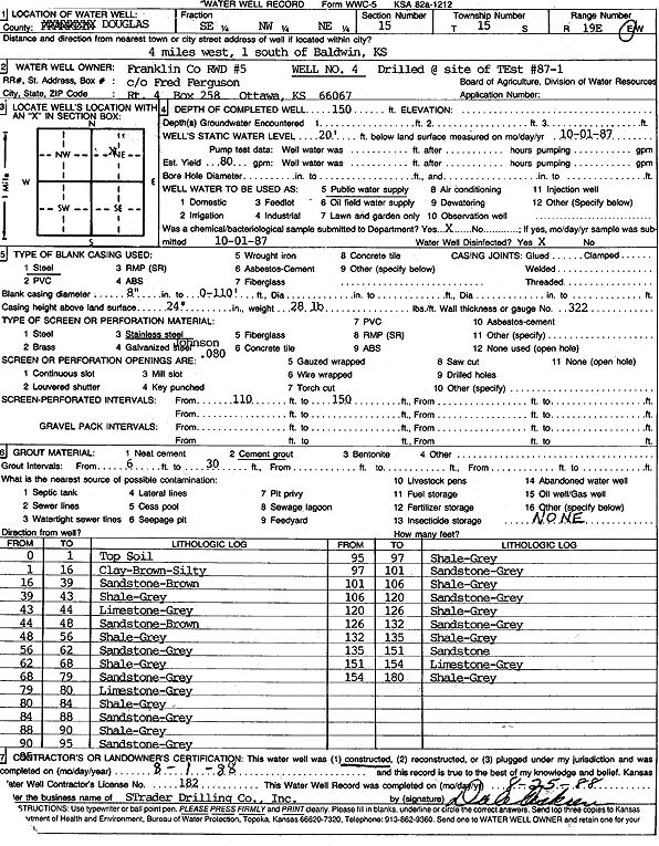
Specific Water Well Detail |
|
|
| Location Info | |||
| Owner: Franklin Co. RWD 5 | Status: Constructed | ||
| Location: T15S, R19E, Sec. 15, SE NW NE | County: Douglas | ||
| Directions: from Baldwin: 4 mi W, 1 mi S | |||
| Latitude: 38.7503871 | Longitude: -95.2843958 | Datum NAD 27 | |
| Latitude: 38.7503942 | Longitude: -95.2846477 | Datum NAD 83 | |
| Longitude and latitude calculated by Survey from township-range-section-quarter calls. Only good to within the quarter call accuracy. | |||
| View well on interactive map | |||
| General Info | ||
| Well Depth: 150 ft. | Elevation: ft. | |
| Static Water Level: 20 ft. | Est. Yield: 80 gpm. | |
| Comp. Date: 01-Aug-1988 | Well Use: Public Water Supply | |
| DWR Applic. #: | Other ID: Well 4 | |
| Links | |
| No Wizard information available. | |
| View info from WIMAS Water Right Data base... | |
| Driller Info | ||
| Driller: Strader Drilling Co., Inc. | License #: 182 | |
| Scanned Form | View scan |
|
Chemical Sample Submitted?: Yes
Water Well disinfected?: | ||
| Ground water encountered: 0 ft. , 0 ft. , 0 ft. | ||
| Pump test data: Well water was 0 ft after 0 hours pumping 0 gpm | ||
| Casing Info | ||
| Casing Type: Steel
Casing Joints: |
Diam: 8 in. to 110 ft
Diam: 0 in. to 0 ft Diam: 0 in. to 0 ft | |
| Casing height above land surface: in
Casing Weight: lbs/ft Wall thickness or gauge no.: | ||
| Screen and Perforation Info | ||
| Screen Type: Stainless Steel | Screen Openings: | |
| Screen-perforated intervals | From: 110 ft to 150 ft
From: 0 ft to 0 ft From: 0 ft to 0 ft | |
| Gravel pack intervals | From: ft to ft | |
| Grout Info | ||
| Grout used: Cement grout | From: 6 to 30 ft
From: 0 to 0 ft From: 0 to 0 ft | |
| Source of Possible Contamination | ||
| Source: | ||
| Direction from well: | Distance: 0 ft | |
| Lithologic Log
(Log data entered by KGS.) | ||
| From: 0 ft. to 1 ft. | top soil | |
| From: 1 ft. to 16 ft. | silty clay, brown | |
| From: 16 ft. to 39 ft. | sandstone, brown | |
| From: 39 ft. to 43 ft. | shale, gray | |
| From: 43 ft. to 44 ft. | limestone, gray | |
| From: 44 ft. to 48 ft. | sandstone, brown | |
| From: 48 ft. to 56 ft. | shale, gray | |
| From: 56 ft. to 62 ft. | sandstone, gray | |
| From: 62 ft. to 68 ft. | shale, gray | |
| From: 68 ft. to 79 ft. | sandstone, gray | |
| From: 79 ft. to 80 ft. | limestone, gray | |
| From: 80 ft. to 84 ft. | shale, gray | |
| From: 84 ft. to 88 ft. | sandstone, gray | |
| From: 88 ft. to 90 ft. | shale, gray | |
| From: 90 ft. to 95 ft. | sandstone, gray | |
| From: 95 ft. to 97 ft. | shale, gray | |
| From: 97 ft. to 101 ft. | sandstone, gray | |
| From: 101 ft. to 106 ft. | shale, gray | |
| From: 106 ft. to 120 ft. | sandstone, gray | |
| From: 120 ft. to 126 ft. | shale, gray | |
| From: 126 ft. to 132 ft. | sandstone, gray | |
| From: 132 ft. to 135 ft. | shale, gray | |
| From: 135 ft. to 151 ft. | sandstone | |
| From: 151 ft. to 154 ft. | limestone, gray | |
| From: 154 ft. to 180 ft. | shale, gray | |