|
|
|
Specific Water Well Detail |
|
|
| Location Info | |||
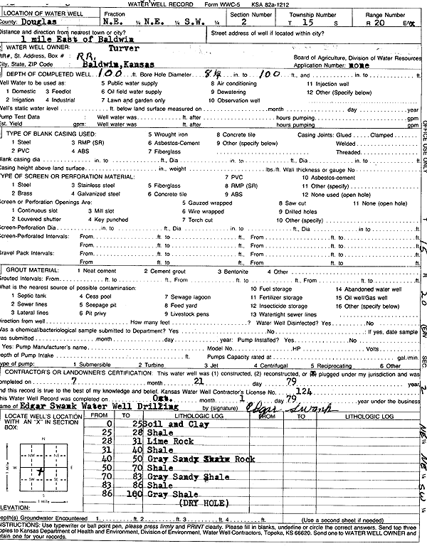
| Owner: Turver | Status: Plugged | ||
| Location: T15S, R20E, Sec. 2, NE NE SW | County: Douglas | ||
| Directions: from Baldwin: 1 mi E | |||
| Latitude: 38.7740049 | Longitude: -95.1592236 | Datum NAD 27 | |
| Latitude: 38.7740122 | Longitude: -95.1594722 | Datum NAD 83 | |
| Longitude and latitude calculated by Survey from township-range-section-quarter calls. Only good to within the quarter call accuracy. | |||
| View well on interactive map | |||
| General Info | ||
| Well Depth: 100 ft. | Elevation: ft. | |
| Static Water Level: ft. | Est. Yield: gpm. | |
| Comp. Date: 21-Jul-1979 | Well Use: Domestic | |
| DWR Applic. #: | Other ID: | |
| Driller Info | ||
| Driller: F. E. Young Drilling Co., Inc. | License #: 240 | |
| Scanned Form | View scan |
| Casing Info | ||
|
Casing Type:
Diam: 0 in. Casing height above land surface: in | ||
| Grout Info | ||
| Grout used: | From: 0 to 0 ft
From: 0 to 0 ft From: 0 to 0 ft | |
| Source of Possible Contamination | ||
| Source: | ||
| Direction from well: | Distance: 0 ft | |
| Lithologic Log
(Log data entered by KGS.) | ||
| From: 0 ft. to 25 ft. | soil and clay | |
| From: 25 ft. to 28 ft. | shale | |
| From: 28 ft. to 31 ft. | lime rock | |
| From: 31 ft. to 40 ft. | shale | |
| From: 40 ft. to 50 ft. | gray sandy rock | |
| From: 50 ft. to 70 ft. | shale | |
| From: 70 ft. to 83 ft. | gray sandy shale | |
| From: 83 ft. to 86 ft. | shale | |
| From: 86 ft. to 100 ft. | gray shale | |