|
|
|
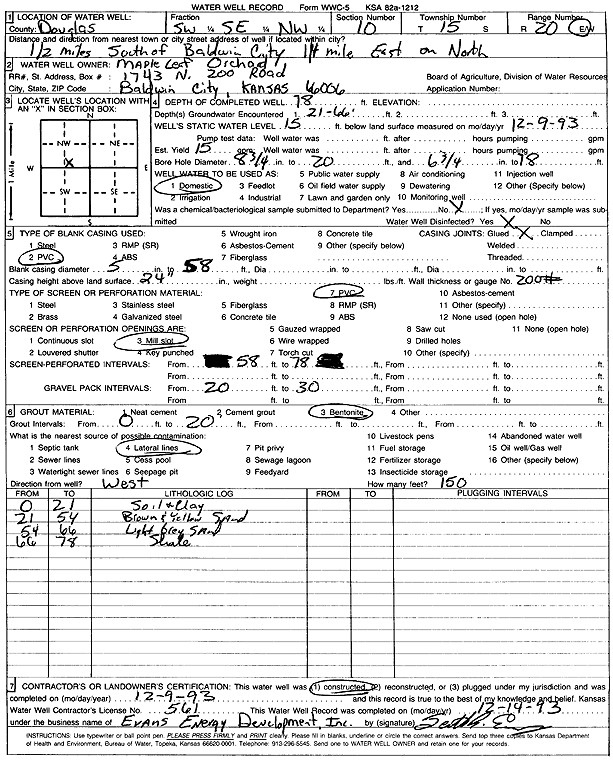
Specific Water Well Detail |
|
|
| Location Info | |||
| Owner: Maple Leaf Orchard | Status: Constructed | ||
| Location: T15S, R20E, Sec. 10, SW SE NW | County: Douglas | ||
| Directions: from Baldwin City: .5 mi S, .25 mi E, N side | |||
| Latitude: 38.7613194 | Longitude: -95.180132 | Datum NAD 27 | |
| Latitude: 38.7613268 | Longitude: -95.1803811 | Datum NAD 83 | |
| Longitude and latitude calculated by Survey from township-range-section-quarter calls. Only good to within the quarter call accuracy. | |||
| View well on interactive map | |||
| General Info | ||
| Well Depth: 78 ft. | Elevation: ft. | |
| Static Water Level: 15 ft. | Est. Yield: 15 gpm. | |
| Comp. Date: 09-Dec-1993 | Well Use: Domestic | |
| DWR Applic. #: | Other ID: | |
| Driller Info | ||
| Driller: Evans Energy Development, Inc. | License #: 561 | |
| Scanned Form | View scan |
|
Chemical Sample Submitted?: No
Water Well disinfected?: | ||
| Ground water encountered: 21 ft. , 66 ft. , 0 ft. | ||
| Pump test data: Well water was 0 ft after 0 hours pumping 0 gpm | ||
| Casing Info | ||
| Casing Type: PVC
Casing Joints: |
Diam: 5 in. to 58 ft
Diam: 0 in. to 0 ft Diam: 0 in. to 0 ft | |
| Casing height above land surface: in
Casing Weight: lbs/ft Wall thickness or gauge no.: | ||
| Screen and Perforation Info | ||
| Screen Type: PVC | Screen Openings: Mill slot | |
| Screen-perforated intervals | From: 58 ft to 78 ft
From: 0 ft to 0 ft From: 0 ft to 0 ft | |
| Gravel pack intervals | From: ft to ft | |
| Grout Info | ||
| Grout used: Bentonite | From: 0 to 20 ft
From: 0 to 0 ft From: 0 to 0 ft | |
| Source of Possible Contamination | ||
| Source: Lateral lines | ||
| Direction from well: | Distance: 0 ft | |
| Lithologic Log
(Log data entered by KGS.) | ||
| From: 0 ft. to 21 ft. | soil and clay | |
| From: 21 ft. to 54 ft. | brown and yellow sand | |
| From: 54 ft. to 66 ft. | light gray sand | |
| From: 66 ft. to 78 ft. | shale | |