|
|
|
Specific Water Well Detail |
|
|
| Location Info | |||
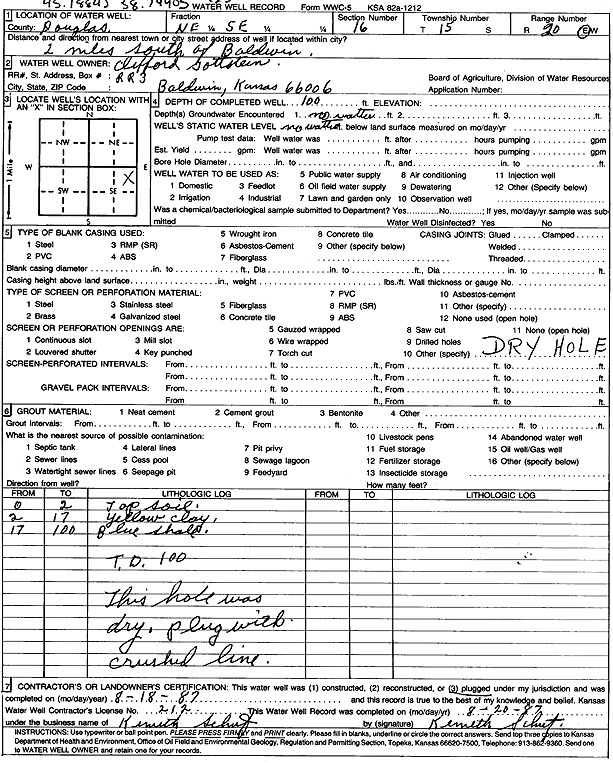
| Owner: Gottstein, Clifford | Status: Plugged | ||
| Location: T15S, R20E, Sec. 16, NE SE | County: Douglas | ||
| Directions: from Baldwin City: 2 mi S | |||
| Latitude: 38.7440467 | Longitude: -95.1884127 | Datum NAD 27 | |
| Latitude: 38.7440546 | Longitude: -95.1886621 | Datum NAD 83 | |
| Longitude and latitude calculated by Survey from township-range-section-quarter calls. Only good to within the quarter call accuracy. | |||
| View well on interactive map | |||
| General Info | ||
| Well Depth: 100 ft. | Elevation: ft. | |
| Static Water Level: ft. | Est. Yield: gpm. | |
| Comp. Date: 18-Aug-1987 | Well Use: (unstated)/abandoned | |
| DWR Applic. #: | Other ID: | |
| Driller Info | ||
| Driller: Kenneth Schutz Drilling | License #: 212 | |
| Scanned Form | View scan |
| Casing Info | ||
|
Casing Type:
Diam: 0 in. Casing height above land surface: in | ||
| Grout Info | ||
| Grout used: | From: 0 to 0 ft
From: 0 to 0 ft From: 0 to 0 ft | |
| Source of Possible Contamination | ||
| Source: | ||
| Direction from well: | Distance: 0 ft | |
| Lithologic Log
(Log data entered by KGS.) | ||
| From: 0 ft. to 2 ft. | top soil | |
| From: 2 ft. to 17 ft. | yellow clay | |
| From: 17 ft. to 100 ft. | blue shale | |