|
|
|
Specific Water Well Detail |
|
|
| Location Info | |||
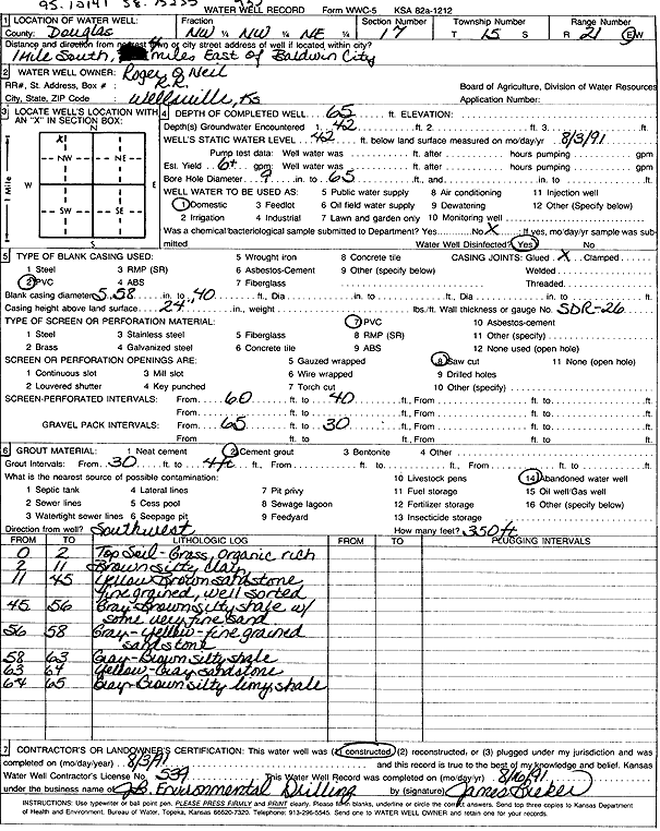
| Owner: O'Neil, Roger | Status: Constructed | ||
| Location: T15S, R21E, Sec. 17, NW NW NE | County: Douglas | ||
| Directions: from Baldwin City: 1 mi S, 4 mi E | |||
| Latitude: 38.7523461 | Longitude: -95.10141 | Datum NAD 27 | |
| Latitude: 38.752354 | Longitude: -95.1016571 | Datum NAD 83 | |
| Longitude and latitude calculated by Survey from township-range-section-quarter calls. Only good to within the quarter call accuracy. | |||
| View well on interactive map | |||
| General Info | ||
| Well Depth: 65 ft. | Elevation: ft. | |
| Static Water Level: 42 ft. | Est. Yield: 6 gpm. | |
| Comp. Date: 03-Aug-1991 | Well Use: Domestic | |
| DWR Applic. #: | Other ID: | |
| Driller Info | ||
| Driller: JB Environmental Drilling | License #: 539 | |
| Scanned Form | View scan |
|
Chemical Sample Submitted?: No
Water Well disinfected?: | ||
| Ground water encountered: 42 ft. , 0 ft. , 0 ft. | ||
| Pump test data: Well water was 0 ft after 0 hours pumping 0 gpm | ||
| Casing Info | ||
| Casing Type: PVC
Casing Joints: |
Diam: 5 in. to 40 ft
Diam: 0 in. to 0 ft Diam: 0 in. to 0 ft | |
| Casing height above land surface: in
Casing Weight: lbs/ft Wall thickness or gauge no.: | ||
| Screen and Perforation Info | ||
| Screen Type: PVC | Screen Openings: Saw cut | |
| Screen-perforated intervals | From: 60 ft to 40 ft
From: 0 ft to 0 ft From: 0 ft to 0 ft | |
| Gravel pack intervals | From: ft to ft | |
| Grout Info | ||
| Grout used: Cement grout | From: 4 to 30 ft
From: 0 to 0 ft From: 0 to 0 ft | |
| Source of Possible Contamination | ||
| Source: Abandoned water well | ||
| Direction from well: | Distance: 0 ft | |
| Lithologic Log
(Log data entered by KGS.) | ||
| From: 0 ft. to 2 ft. | top soil, grass, organic rich | |
| From: 2 ft. to 11 ft. | brown silty clay | |
| From: 11 ft. to 45 ft. | yellow brown fine sandstone, well sorted | |
| From: 45 ft. to 56 ft. | gray brown silty shale with some very fine sand | |
| From: 56 ft. to 58 ft. | gray yellow fine sandstone | |
| From: 58 ft. to 63 ft. | gray brown silty shale | |
| From: 63 ft. to 64 ft. | yellow gray sandstone | |
| From: 64 ft. to 65 ft. | gray brown silty limey shale | |