|
|
|
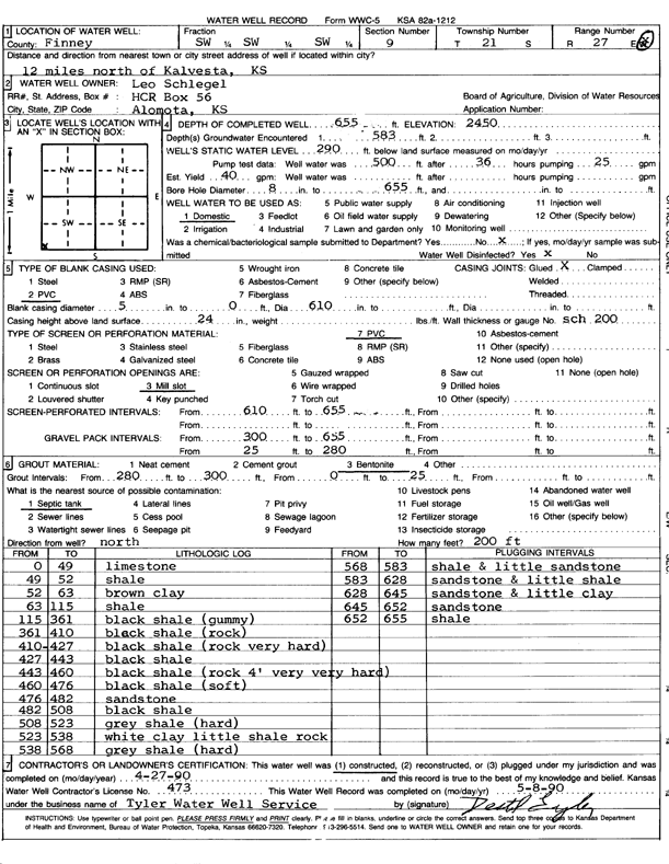
Specific Water Well Detail |
|
|
| Location Info | |||
| Owner: Schlegel, Leo | Status: Constructed | ||
| Location: T21S, R27W, Sec. 9, SW SW SW | County: Finney | ||
| Directions: from Kalvesta, 12 mi N | |||
| Latitude: 38.2345715 | Longitude: -100.2987924 | Datum NAD 27 | |
| Latitude: 38.2345893 | Longitude: -100.2992086 | Datum NAD 83 | |
| Longitude and latitude calculated by Survey from township-range-section-quarter calls. Only good to within the quarter call accuracy. | |||
| View well on interactive map | |||
| General Info | ||
| Well Depth: 655 ft. | Elevation: 2450 ft. | |
| Static Water Level: 290 ft. | Est. Yield: 40 gpm. | |
| Comp. Date: 27-Apr-1990 | Well Use: Domestic | |
| DWR Applic. #: | Other ID: | |
| Driller Info | ||
| Driller: Tyler Water Well Service | License #: 473 | |
| Scanned Form | View scan |
|
Chemical Sample Submitted?: No
Water Well disinfected?: | ||
| Ground water encountered: 583 ft. , 0 ft. , 0 ft. | ||
| Pump test data: Well water was 500 ft after 36 hours pumping 25 gpm | ||
| Casing Info | ||
| Casing Type: PVC
Casing Joints: |
Diam: 5 in. to 610 ft
Diam: 0 in. to 0 ft Diam: 0 in. to 0 ft | |
| Casing height above land surface: in
Casing Weight: lbs/ft Wall thickness or gauge no.: | ||
| Screen and Perforation Info | ||
| Screen Type: PVC | Screen Openings: Mill slot | |
| Screen-perforated intervals | From: 610 ft to 655 ft
From: 0 ft to 0 ft From: 0 ft to 0 ft | |
| Gravel pack intervals | From: ft to ft | |
| Grout Info | ||
| Grout used: Bentonite | From: 0 to 25 ft
From: 280 to 300 ft From: 0 to 0 ft | |
| Source of Possible Contamination | ||
| Source: Septic Tank | ||
| Direction from well: | Distance: 0 ft | |
| Lithologic Log
(Log data entered by KGS.) | ||
| From: 0 ft. to 49 ft. | limestone | |
| From: 49 ft. to 52 ft. | shale | |
| From: 52 ft. to 63 ft. | brown clay | |
| From: 63 ft. to 115 ft. | shale | |
| From: 115 ft. to 361 ft. | black shale (gummy) | |
| From: 361 ft. to 410 ft. | black shale (rock) | |
| From: 410 ft. to 427 ft. | black shale (rock very hard) | |
| From: 427 ft. to 443 ft. | black shale | |
| From: 443 ft. to 460 ft. | black shale (rock 4 feet very very hard) | |
| From: 460 ft. to 476 ft. | black shale (soft) | |
| From: 476 ft. to 482 ft. | sandstone | |
| From: 482 ft. to 508 ft. | black shale | |
| From: 508 ft. to 523 ft. | gray shale (hard) | |
| From: 523 ft. to 538 ft. | white clay little shale rock | |
| From: 538 ft. to 568 ft. | gray shale (hard) | |
| From: 568 ft. to 583 ft. | shale and little sandstone | |
| From: 583 ft. to 628 ft. | sandstone and little shale | |
| From: 628 ft. to 645 ft. | sandstone and little clay | |
| From: 645 ft. to 652 ft. | sandstone | |
| From: 652 ft. to 655 ft. | shale | |