|
|
|
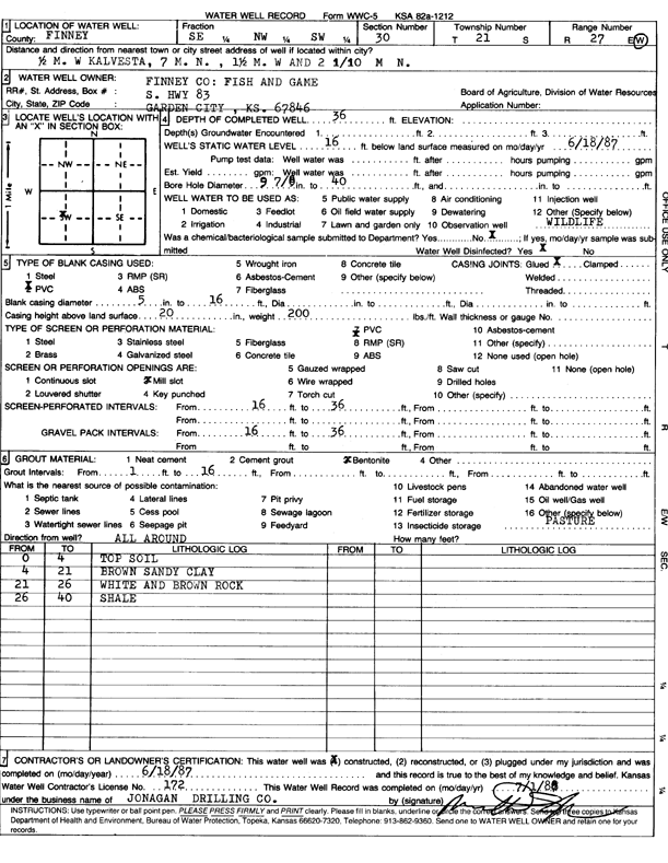
Specific Water Well Detail |
|
|
| Location Info | |||
| Owner: Finney County Fish and Game | Status: Constructed | ||
| Location: T21S, R27W, Sec. 30, SE NW SW | County: Finney | ||
| Directions: from Kalvesta, 0.5 mi W, 7 mi N, 1.5 mi W, and 2.1 mi N | |||
| Latitude: 38.1944769 | Longitude: -100.3322633 | Datum NAD 27 | |
| Latitude: 38.1944953 | Longitude: -100.3326809 | Datum NAD 83 | |
| Longitude and latitude calculated by Survey from township-range-section-quarter calls. Only good to within the quarter call accuracy. | |||
| View well on interactive map | |||
| General Info | ||
| Well Depth: 36 ft. | Elevation: ft. | |
| Static Water Level: 16 ft. | Est. Yield: gpm. | |
| Comp. Date: 18-Jun-1987 | Well Use: Pond/Swimming Pool/Recreation | |
| DWR Applic. #: | Other ID: | |
| Driller Info | ||
| Driller: Jonagan Drilling Company | License #: 172 | |
| Scanned Form | View scan |
|
Chemical Sample Submitted?: No
Water Well disinfected?: | ||
| Ground water encountered: 0 ft. , 0 ft. , 0 ft. | ||
| Pump test data: Well water was 0 ft after 0 hours pumping 0 gpm | ||
| Casing Info | ||
| Casing Type: PVC
Casing Joints: |
Diam: 5 in. to 16 ft
Diam: 0 in. to 0 ft Diam: 0 in. to 0 ft | |
| Casing height above land surface: in
Casing Weight: lbs/ft Wall thickness or gauge no.: | ||
| Screen and Perforation Info | ||
| Screen Type: PVC | Screen Openings: Mill slot | |
| Screen-perforated intervals | From: 16 ft to 36 ft
From: 0 ft to 0 ft From: 0 ft to 0 ft | |
| Gravel pack intervals | From: ft to ft | |
| Grout Info | ||
| Grout used: Bentonite | From: 1 to 16 ft
From: 0 to 0 ft From: 0 to 0 ft | |
| Source of Possible Contamination | ||
| Source: OTHER | ||
| Direction from well: | Distance: 0 ft | |
| Lithologic Log
(Log data entered by KGS.) | ||
| From: 0 ft. to 4 ft. | top soil | |
| From: 4 ft. to 21 ft. | brown sandy clay | |
| From: 21 ft. to 26 ft. | white and brown rock | |
| From: 26 ft. to 40 ft. | shale | |