|
|
|
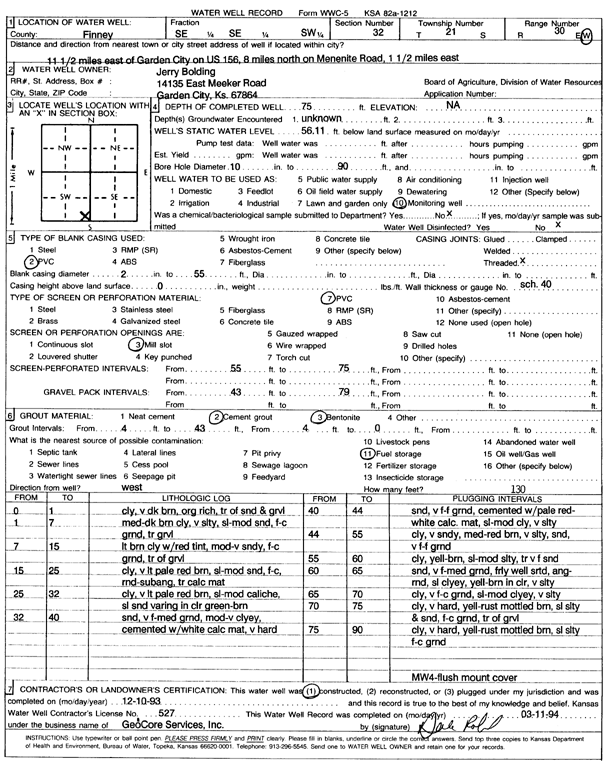
Specific Water Well Detail |
|
|
| Location Info | |||
| Owner: Bolding, Jerry | Status: Constructed | ||
| Location: T21S, R30W, Sec. 32, SE SE SW | County: Finney | ||
| Directions: 11.5 mi E of Garden City on US 156, .8 mi N on Mennonite Rd, 1.5 mi E | |||
| Latitude: 38.1778452 | Longitude: -100.6379254 | Datum NAD 27 | |
| Latitude: 38.1778655 | Longitude: -100.638353 | Datum NAD 83 | |
| Longitude and latitude calculated by Survey from township-range-section-quarter calls. Only good to within the quarter call accuracy. | |||
| View well on interactive map | |||
| General Info | ||
| Well Depth: 75 ft. | Elevation: ft. | |
| Static Water Level: 56.11 ft. | Est. Yield: gpm. | |
| Comp. Date: 10-Dec-1993 | Well Use: Monitoring well/observation/piezometer | |
| DWR Applic. #: | Other ID: MW 4 | |
| Driller Info | ||
| Driller: GeoCore Services Inc. | License #: 527 | |
| Scanned Form | View scan |
|
Chemical Sample Submitted?: No
Water Well disinfected?: | ||
| Ground water encountered: 0 ft. , 0 ft. , 0 ft. | ||
| Pump test data: Well water was 0 ft after 0 hours pumping 0 gpm | ||
| Casing Info | ||
| Casing Type: PVC
Casing Joints: |
Diam: 2 in. to 55 ft
Diam: 0 in. to 0 ft Diam: 0 in. to 0 ft | |
| Casing height above land surface: in
Casing Weight: lbs/ft Wall thickness or gauge no.: | ||
| Screen and Perforation Info | ||
| Screen Type: PVC | Screen Openings: Mill slot | |
| Screen-perforated intervals | From: 55 ft to 75 ft
From: 0 ft to 0 ft From: 0 ft to 0 ft | |
| Gravel pack intervals | From: ft to ft | |
| Grout Info | ||
| Grout used: Cement grout, Bentonite | From: 0 to 4 ft
From: 4 to 43 ft From: 0 to 0 ft | |
| Source of Possible Contamination | ||
| Source: Fuel storage | ||
| Direction from well: | Distance: 0 ft | |
| Lithologic Log
(Log data entered by KGS.) | ||
| From: 0 ft. to 1 ft. | clay, very dark brown organic rich, trace of sand and gravel | |
| From: 1 ft. to 7 ft. | medium dark brown clay, very silty, slightly moderate sand, fine to coarse grained, trace gravel | |
| From: 7 ft. to 15 ft. | light brown clay with red tint, moderate-very sandy, fine-coarse grained, trace of gravel | |
| From: 15 ft. to 25 ft. | clay, very light pale red brown, slightly moderate sand, fine-coarse, medium-sub angular, trace caliche mat | |
| From: 25 ft. to 32 ft. | clay, very light pale red brown, slightly-moderate caliche, sl sand varying in color green-brown | |
| From: 32 ft. to 40 ft. | sand, very fine-medium grained, moderate-very clayey, cemented with white caliche material, very hard | |
| From: 40 ft. to 44 ft. | sand, very fine-fine grained, cemented with pale red-white caliche material, slightly-moderate clay, very silty | |
| From: 44 ft. to 55 ft. | clay, very sandy, medium-red brown, very silty, sand, very fine-fine grained | |
| From: 55 ft. to 60 ft. | clay, yellow-brown, slightly-moderate silty, trace very fine sand | |
| From: 60 ft. to 65 ft. | sand, very fine-medium grained, fairly well sorted, angular-medium, slightly clayey, yellow-brown in color, very silty | |
| From: 65 ft. to 70 ft. | clay, very fine-coarse, slightly-moderate clayey, very silty | |
| From: 70 ft. to 75 ft. | clay, very hard, yellow-rust mottled brown, slightly silty and sand, fine-coarse grained, trace of gravel | |
| From: 75 ft. to 90 ft. | clay, very hard, yellow-rust mottled brown, slightly silty fine-coarse grained | |